¶ Management of Forest Landscapes
¶ What is a Forest Landscape?
A forest landscape is a geographical area of any size, where a forest is a key vegetation component. It may refer to an area with interconnected forests or ecosystems, and therefore, “landscape” and “ecosystem” are often used interchangeably. Landscapes are delineated on the ground depending on the management objectives, land use systems. The landscape may be one forest and its environs, or several forests in a given geographical area, connected through a variety of land uses. In practice, forest landscapes in Uganda can be interpreted to refer to:
• Areas delineated for purposes of conservation of biological diversity e.g. the Albertine Rift Forests
• The four Water Management Zones of the MWE, with a Regional Forest Office in each Zone
• The Uganda Bio-geographical Provinces delineated in the Uganda Country Study on Costs, Benefits and Unmet Needs of Biological Diversity Conservation (UNEP, 1992)
• The seven landscapes delineated in the Forest Landscape Restoration Opportunity Assessment for Uganda (MWE & IUCN, 2016)
• Uganda’s nine Agro-ecological Zones
• NFA’s nine Administrative Ranges or each sector under each of those Ranges (NFA Strategic Plan, 2020-2025)
• Forest Management Plan Areas that cover a number forests
• Etc.
¶ Principles of the Landscape Approach
A landscape approach to managing forests provides opportunities for managing land to achieve social, economic, and environmental objectives amidst land uses that interact with forestry. Such land uses commonly include agriculture, livestock, wildlife, mining, watersheds, fisheries, wetlands, among others.
The 10 principles of the landscape approach to natural resource management outlined below have been widely discussed through intergovernmental and inter-institutional processes, and accepted by the Convention on Biological Diversity, to which Uganda is a signatory.
The principles point to how agricultural production and environmental conservation can best be integrated at a landscape scale [1].
(i) Principle 1: Continual learning and adaptive management
Because there are a number of components in a landscape, implementers continuously learn during implementation and this learning goes beyond forestry to the disciplines that interact with forestry. As new knowledge becomes available from a variety of interventions, actions are revised accordingly.
(ii) Principle 2: Common concern entry point
Solutions to problems need to be built on shared negotiation processes based on trust among the actors. Trust emerges when objectives and values are shared. However, full consensus is often difficult to achieve because stakeholders have different values, beliefs, and objectives. Therefore identifying immediate ways forward through addressing simpler short-term objectives can begin to build trust. Each stakeholder will only join the process if they judge it to be in their interest. Launching the process by focusing on easy-to-reach intermediate targets may provide a basis for stakeholders to begin to work together.
(iii) Principle 3: Multiple scales
Multiple processes at various levels affect the overall landscape approach. Awareness of these processes can improve local interventions, inform higher-level policy and governance, and help coordinate administrative entities.
(iv) Principle 4: Multi-functionality
Many landscapes provide a diverse range of values, goods, and services. The landscape approach acknowledges the various tradeoffs among these goods and services.
(v) Principle 5: Multiple stakeholders
Multiple stakeholders frame and express objectives in different ways. Stakeholders should therefore be engaged equitably in decision-making processes. All stakeholders should be recognized, even though efficient pursuit of negotiated solutions may involve a subset of the stakeholders. Solutions should encompass a fair distribution of benefits and incentives. Progress requires communication, which needs to be developed and nurtured, and mutual respect of values is essential. There is often a need to address conflicts, and issues of trust and power.
(vi) Principle 6: Negotiated and transparent change logic
Trust among stakeholders is a basis for good management and is needed to avoid or resolve conflicts. Transparency is the basis of trust, and is achieved through a mutually understood and negotiated process of change, helped by good governance. The need to coordinate activities by diverse actors requires that a shared vision can be agreed upon, and achieving broad consensus on general goals, challenges, and concerns, as well as on options and opportunities. All stakeholders need to understand and accept the general logic, legitimacy, and justification for a course of action, and to be aware of the risks and uncertainties. Building and maintaining such a consensus is a fundamental goal of a landscape approach
(vii) Principle 7: Clarification of rights and responsibilities
Rules on access to resources and land use need to be clear as a basis for good management. Access to a fair justice system allows for conflict resolution and recourse. The rights and responsibilities of different actors need to be clear to, and accepted by, all stakeholders. When conflict arises, there needs to be an accepted legitimate system for arbitration, justice, and reconciliation.
(viii) Principle 8: Participatory and user-friendly monitoring
In a landscape approach, no single stakeholder can claim to have all the relevant information. All stakeholders should be able to generate, gather, and integrate the information they require to interpret activities, progress, and threats. To facilitate shared learning, information needs to be widely accessible, systems that integrate different kinds of information need to be developed and used. When stakeholders have agreed on desirable actions and outcomes, they should also be involved in assessing progress, and updating the theory of change on which the landscape approach is based
(ix) Principle 9: Resilience
Actions need to be promoted that address threats and that allow recovery after disturbances. Resilience may be improved through local learning and through drawing lessons from elsewhere
(x) Principle 10: Strengthened stakeholder capacity
People require the ability to participate effectively and to accept various roles and responsibilities. Such participation presupposes certain skills and abilities (social, cultural, financial). The complex and changing nature of landscape processes requires competent and effective representation and institutions that are able to engage with all the issues raised by the process.
¶ Forest Landscape Planning and Implementation
This section is based on: Implementing a Landscape Approach in the Agoro-Agu Region of Uganda, by J. Omoding, et al, 2020[2]. In this case, the Agoro Agu Landscape included the whole of NFA’s Agoro Agu Sector, which covers the four districts in the East Acholi Sub-region.
(i) Constituting the planning team
• Identify key stakeholders at the national, regional and local level and from public and private institutions and civil society. They may include forestry sector staff, private sector, CSOs, Central Government staff, District LG technical staff, political leaders, opinion leaders, etc.
• Holding an orientation meeting to introduce the team to the forest and landscape management planning guidelines, the general approach to be used, and training on participatory rural appraisal tools
(ii) Data collection and processing
Covers the entire landscape (district, sub‐county, parish, village levels), connectivity with agricultural land systems, wildlife conservation areas, wetlands, and other land use practices. Activities include:
• Designing tools including interview guides, focus group discussions, presentations to district and sub-county level meetings, planning matrices for environment action planning and forest resources evaluation and valuation matrix, timeline for tracking historical trends, and resource maps for each district
• Constructing a landscape planning knowledge base
• Conducting land use planning analysis using participatory rural appraisal and GIS
• Completing a social and strategic environmental assessment, and understanding the spatial-temporal changes.
• Data processing involving GIS experts, District technical staff, CSOs, political representatives, etc.
(iii) Developing actions based on an established vision
Participatory development of the framework Theory of Change for the landscape, through stakeholder engagements in each district and at the lower LG units
(iv) Development and validation of the Forest Landscape Management Plan
Members of the Planning Team are involved in writing the management plans based on the data collected and the framework Theory of Change. A number of plans may be developed from the data gathered: FMPs for the CFRs, and District Forestry Development Plans (including LFRs), Local Land Use Plans, and a Strategic Landscape Management Plan encompassing all the other plans
(v) Approval of Forest and Landscape Management Plans
The plans are approved in accordance with the legal provisions – NFA Board for CFRs, LG Councils for the other plans. The activities in the plans will then be integrated into the LG Development Plans.
(vi) Implementation of the Plan
Translate the 10 Principles of the landscape approach described in Section 3.6.2 above into activities on the ground. For more detail on the methods, see J. Omoding, et al, 2020 quoted above
Instruction 116: Forest management planning shall take the landscape planning approach. This approach shall apply to preparation of FMPs, District Forestry Development Plan (DFDPs) and Annual Work Plans. Regional Forest Officers and NFA Range Managers shall be the main lead actors in planning and implementation of the forest landscape management plans
¶ Forest Management Based on the Intended Main Product or Service
In managing forest landscapes, it is important that FMIs are clear about what the main final products or services will be, and thus, design the forest landscape management objectives accordingly. Other products and services can then be planned around the main products/ services as secondary products/ services. For example if the main final product of the natural forest component in the landscape is sawlogs for high grade furniture timber, the species chosen for restoration of the degraded/ deforested areas may be Afzelia, Khaya, Maesopsis, Tectona spp, etc. or a mix of these species. Secondary products/ services of the forest in the landscape may then be expressed in objectives that include management of the forest for biodiversity conservation, watershed services, carbon sequestration, non-timber forest products, etc.
Additionally, the objectives of management based on the products and services provide guidance on the management options and detailed activities, all geared towards the achievement of the desired products and services. For example, the objectives for a plantation component in the landscape will guide the selection or choice of a tree species to be grown, the method to be used (e.g. natural regeneration or planting seedlings), etc. The detailed management activities are usually based on the best practice and technical guidance for effective achievement of the desired products and services.
More specifically, urban and peri-urban forest reserves have previously been managed with the objectives of providing forest products like timber, poles, and firewood, among others. These objectives tend to target the urban and peri-urban low income earners. While these objectives are noble, the reserves will be more sustainable if they are also managed from the point of view of recreation and enhancing the cleanliness of the urban environment. Implementing such objectives will then accept physical structures that would normally not be readily acceptable in the FRs located in rural areas (e.g. restaurants, children play areas, facilities for wedding parties, etc.). This will cater for the low income segment of the urban population, but the high income segment (where major policy decisions are mooted and taken) will also recognise values that cannot be met by money alone. This will also generate much more revenue for the FMIs (mainly through presenting opportunities for small to medium scale business opportunities), than what is being earned from poles and firewood. Therefore there will be a need for focused restoration work in the urban and peri-urban FRs to provide for these objectives.
Instruction 117: The main management objective for urban and peri-urban FRs shall be recreation and providing a clean and healthy urban environment, with the associated objectives of education, research, biodiversity, clean water, and timber and non-timber forest products.
¶ Management of Forests for Biodiversity Conservation
Biodiversity conservation is the practice of protecting, preserving, and wisely using species, habitats, ecosystems, and genetic diversity on earth. It is important for our health, wealth, food, fuel, and services we depend on, and thus, biodiversity plays a crucial role in supporting economic growth and the general wellbeing of society at local, national, and global levels. Biodiversity conservation, together with other SFM practices reduce the amount of greenhouse gases (GHGs) released into the atmosphere.
¶ Forest Biodiversity Conservation Master Plan
The Forestry Nature Conservation Master Plan, 2002 (FNCMP) provides for management of biodiversity, with particular focus on forests in PAs. The Plan has zoned the forest estate as shown in Table 4.
Table 4: Areas of Strict Nature Reserves and Buffer Zones in Uganda’s CFRs
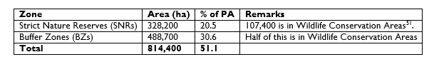
Source: Ministry of Water, Lands and Environment, Forest Department, 2002. Uganda Forestry Nature Conservation Master Plan, June 2002.[3]
About 45 forests host the conservation sites. Eight are categorized as being of “prime conservation importance”, 11 of “core conservation importance”, and 26 of “secondary conservation importance” (Table 5)
Table 5: Areas Set Aside For Biodiversity Conservation in Uganda
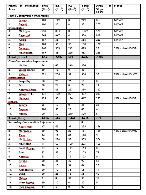
Source: Uganda Forest Nature Conservation Master Plan, 2002.
Twenty-seven of the conservation forests have been categorized as sites of critical biodiversity importance by the FNCMP, and 57% of the conservation area (SNRs & BZs) is located in CFRs.
Management practices for the conservation sites have been elaborated in Chapter 4 of the FNCMP. Key among the provisions for each forest where conservation zones are located include:
(i) Development and establishment of locally-acceptable zones;
(ii) Roles and responsibilities of different stakeholders in management decision-making and implementation;
(iii) General management procedures, including boundary demarcation, patrolling, community outreach, research and monitoring, ecosystem management;
(iv) Requirements for management of infrastructure and facilities;
(v) Specific requirements for Nature Reserve designation, demarcation and management;
(vi) Protection and management procedures for other conservation areas;
(vii) Conservation aspects of management within timber production zones; and
(viii) Institutional arrangements for implementation of the FNCMP.
Instruction 118: The FNCMP shall be reviewed and re-structured into a “Forest Biodiversity Conservation Master Plan” and kept regularly updated using Best Available Information, sourced from monitoring and evaluation activities of FMI work plans and projects.
Instruction 119: The provisions of the FNCMP have been translated into Programmes and Strategies in the NFP. The strategies shall be internalized in FMPs and DFDPs, which shall be the basis for preparation of annual work plans (AWPs) and budgets at national and District LG levels.
Instruction 120: In addition, the following actions should be taken into account in the management of forests for biodiversity conservation[4]:
(i) Before areas are designated as production areas, surveys shall be conducted to identify any high conservation values that are found in the area so that actions can be planned for their maintenance and/or improvement.
(ii) Retain as much of the natural biodiversity of any forest under management as possible in order to ensure the continued functioning of the forest ecosystem.
(iii) Where possible, create or maintain habitat corridors between blocks of forest to permit the movement of forest interior species including, e.g. creating buffer strips along water bodies, retaining canopy connectivity over roads and crossing points on roads, etc.
(iv) Ensure clarity of boundaries of local use areas and access rights for timber, non-timber forest products, fish and wildlife
(v) Studies of the ecology and habitat requirements of species of conservation concern should be incorporated in the management of production areas in tropical moist forests.
(vi) Patches of habitats with high species diversity or other special conservation values should be identified within tropical production forests and special measures taken to ensure the retention of these values.
(vii) Maintain unlogged buffer strips around fire prone areas.
(viii) Pre-logging inventories (stock maps etc) should identify and map species and assemblages of species of conservation concern, such as nesting and fruit bearing trees, and other important biodiversity features.
(ix) Protective buffer zones should be created along water courses of a dimension appropriate to the size of the watercourse and the nature of local topography
(x) Avoid the deliberate introduction of species that may be invasive and take prompt action to eliminate any populations of invasive species that may become established.
(xi) Manage plantations in ways that retain patches/strips of natural vegetation such as riverine forests, wetland forests, shrubs and thickets on steep hill slopes, etc., and manage them for production or provision of environmental services.
¶ Action Planning for Threatened/ Endangered Species
Uganda is blessed with a rich diversity of natural habitats, species and genetic resources in its forests. This biodiversity is also important to human health and wealth, for example by providing traditional plant medicines, wild relatives of domestic plants, a variety of ecosystems and species important in the tourism industry, and potential opportunities for Ugandans to adapt to local and global change. And yet, forest biodiversity is under threat from:
• Unsustainable harvesting, habitat conversion, the introduction of alien species and pollution;
• Illegal trade in plants and animals, including poorly regulated access to genetic resources;
• Poor forest governance which results in:
o Unprincipled giveaway of PA lands,
o Exploitation of forests arising from poor administration of the FMIs,
o Inadequate demonstration of the importance of biodiversity in the annual plans and budgets of FMIs
Threatened tree species in Uganda for which action plans are urgently needed include, among others[5], Albizia ferruginea, Aloe spp, Cordia millenii, Encephalartos spp (cycads), Entandrophragma spp, Guarea cedrata, Khaya spp, Lovoa spp, Milicia excelsa, Afzelia bipindensis, Beilschmiedia ugandensis, Calamus deerratus (rattan cane), Chrysophyllum spp, Citropsis articulate, Cola congolana, Dalbergia melanoxylon, Erythrophleum suaveolens, Fagaropsis angolensis, Olea welwitschii, Podocarpus latifolius, Prunus Africana, Tamarindus indica, and Vitellaria paradoxa. A more detailed list of threatened species in Uganda, and the geographical locations in Uganda, is contained in the Red List of Threatened Species of Uganda, 2018.
One of the pressing challenges facing biodiversity conservation, and by implication the conservation of threatened species, is how to balance the continued survival of biodiversity in the face of the political economy existing in the country. However, the Forestry Policy recognises that the current PFE contains most of the country's valuable biodiversity. The policy provides for gazetting of additional areas where these areas are identified as being of national significance for biodiversity conservation or protection of watersheds, riverbanks and lakeshores, and would be better managed as PAs.
Instruction 121: In Uganda, the IUCN Guidelines for Conservation of Species[6] can be used in one or more of the following key situations with reference to forest ecosystems and landscapes:
• A species has been observed to be declining in numbers
• New threats have appeared, and or existing threats are intensifying
• A significant habitat loss or fragmentation has occurred
• When a population is threatened by major disruption of its habitat or ability to carry on an undisturbed existence through a proposed major land use change, such as through infrastructure development
• During an ESIA or Social and Biodiversity Impact Assessment exercise
• When a population is subject to significant harvesting, whether legal or illegal
Instruction 122: Priority for species action planning undertaken by FPs should target the high furniture grade timber species. The action plans shall be included in the relevant FMPs and updated regularly as scientific information about the species continues to unfold.
The main pressures to threatened species populations are habitat destruction and the extraction of wild plants for timber, horticultural and collector trade. However, these actions are often influenced by the broader society where the demand for natural resources, through mining and agriculture, results in habitat destruction and the international trade in threatened species (often illegal) creates a demand for wild collected plants. The challenge for threatened species is to identify these forces and to develop and implement conservation strategies that will be effective within the context of these local, national, and international dynamics. To this end:
Instruction 123: Species action planning should be done early in the planning cycles so that it can feed into the main national and LG development planning frameworks. In a similar manner the activities in the Species Action Plan shall be incorporated into the FMPs, the DFDPs, District Environment Action Plans, and consequently into the AWPs of the Government FMIs
Instruction 124: Species action planning shall involve key stakeholders, including the relevant government institutions, Public Sector Organisations, CSOs, academic institutions, research institutions, and cultural institutions, among others
Instruction 125: The content of a species action plan shall take into account, but shall not be limited to the activities listed below. The actual content of the species action plan will then be guided by the amount of information that is available, the species focus for the action plan, and the resources (expertise and finances), among others
(a) Develop links with organizations focusing on biodiversity hotspots to maximize synergies
(b) Identify threatened species in accordance with the IUCN Red List Categories and Criteria: Version 3.1[7].
(c) Raise the planting material for ex situ species conservation in the nurseries, mainly from wildlings of the threatened species
(d) Plant them ex situ or as part of restoration of degraded forest areas
(e) Conduct an inventory of existing botanical gardens and arboreta
(f) Undertake the necessary studies to site arboreta/ botanical gardens and establish the institutional arrangements for them
(g) Strengthen existing gardens and arboreta and establish new ones
(h) Develop and implement a protocol for duplicate collections and exchange of material between gardens/ arboreta housing threatened species gene banks
(i) Review current trade (legal and illegal) and its impact on wild populations
(j) Facilitate sustainable trade in threatened species
(k) Develop a conservation culture among threatened species collectors and their promoters
(l) Survey threatened species populations
(m) Support the study on persistence of small populations and identify the key factors influencing decline and recovery
(n) Identify the best methods for the propagation and cultivation of species that are threatened by trade.
(o) Disseminate the results of existing and future research work on threatened species
More detailed guidance on species conservation planning may be obtained from the IUCN Guidelines for Species Conservation Planning[8].
¶ Threat Reduction Assessment for Measuring Progress in Biodiversity Conservation
For purposes of biodiversity conservation, a total of 66 CFRs in Uganda have been categorised as of Prime, Core, or Secondary conservation value. Some of the key activities prescribed for these CFRs by the FNCMP involve forest protection. Consequently, Government FMIs (especially NFA and UWA) have continued to prioritise forest protection in terms of resource allocation (budget, vehicles, and personnel).
In the foreseeable future, the NFA and UWA will continue to spend an appreciable amount of money on protection of natural forests, especially for purposes of biodiversity conservation and general ecosystem integrity. In addition, the performance of these institutions is going to be judged more and more through their achievements in protecting the natural forests in PAs.
On the other hand, the NFA has been working towards RFM which can be independently verified, eventually leading to international forest certification. However, a significant challenge has been how to specify indicators that demonstrate visible progress in effective protection of natural forests. Therefore in order to demonstrate specific results of forest protection, activities to establish and monitor specific threats to particular forests at FMU level is the subject of threat reduction assessment (TRA). The TRA is carried out at pre-determined intervals, depending on the degree of threats faced by a FMU.
Accordingly, NFA has developed a Field Manual for Threat Reduction Assessment. Using the Manual, the FP will be able to:
• Understand the importance of monitoring threats to natural forests at FMU level
• Design and carry out TRA at FMU level
• Develop a monitoring and evaluation framework for managing identified threats
The practical problem has been the difficulty of demonstrating in specific terms the results of the protection activities. The ultimate results of the TRA is a Threat Reduction Index. The index is developed by ranking each identified threat according to specific criteria, and assessing progress in reducing each of the threats. The Threat Reduction Index then aggregates the assessments of individual threats
The detailed field procedure [9] is provided in the TRA field manual available at the NFA. The manual was developed during a series of field training exercises that were based on Richard Margoluis and Nick Salafsky, 2001[10].
Although the procedure was developed with biodiversity conservation in mind, it can also be used for monitoring threats in production areas of natural forests.
Instruction 126: FMU staff shall use the NFA Field Manual to design TRA programmes for the relevant FMUs, which shall be used to monitor progress in achieving some of the biodiversity conservation objectives. The assessments shall be carried out at least once every two years and the results shall feed into the NFIMS (Section 9.9), and the monitoring and evaluation arrangements of the FMI (Section 10.10).
¶ Management of Forest Vegetation for Watershed Functions
The regulation of water quantity and quality is among the most important forest ecosystem services in Uganda. The Society of American Foresters (2020)[11] states that forests are a fundamental component of the hydrological cycle because they “capture, filter, store, and release water over time”. Tree canopies intercept rainfall and thus, reduce the speed and energy of raindrops that fall to the forest floor, and in the process protect the soil surface from water erosion. On the other hand, forest soils absorb large amounts of water that reach the ground, leading to recharge of underground aquifers. This water is then slowly released into streams, lakes, and rivers, providing a steady supply of water for production and human use. In addition, well managed forests filter surface runoff, and thus enhance the quality of water in the streams, rivers and lakes.
¶ Management of Forest Vegetation for Increased Water Yield
In general, water infiltration and retention are encouraged in forest soils by dense, deep root systems and a thick and porous organic top layer. Surface runoff is, therefore, minimal in forests and groundwater recharge is efficient, resulting in more consistent stream flows over time compared with any other land cover.
Instruction 127: To support this regulating function of forests, forest managers should identify the micro-catchment areas for important water sources in their jurisdiction and prepare catchment management plans (Module Two, Section 6.8) with the following possible activities, among others:
• Protect or restore vegetation cover (indigenous tree species mixed with shrubs and grass cover, as appropriate).
• Where there is compaction of soils (e.g. through overgrazing or movement of machines), adopt practices that loosen surface soils (e.g. deep cultivation, control of cattle numbers, and adoption of low impact harvesting methods (Section 3.1)
• Where agricultural crops are being grown, adopt agroforestry practices that maintain a high amount of organic matter in the soil, and improve soil structure, which helps increase water infiltration.
• Seek collaboration with the relevant staff and CSOs in the district (e.g. agricultural extension and community development)
Apart from total yield, the watershed manager is also concerned with when the increase comes. There may be specific times when downstream quantities are not enough for the needs there. It may also be necessary to maintain minimum quantities for upstream services.
Instruction 128: Therefore, adopt the treatments in the instruction above to augment underground storage so that there is enough water for dry season flows. Time vegetation removal with periods of maximum growth rates and not the dry season when there is no precipitation to seep into the soil.
¶ Management of Vegetation for Water Quality
Water from undisturbed forest is of the highest quality for downstream communities. As the water moves downstream through degraded forestlands, the quality of water tends to drop. This may be due to sedimentation arising out of soil eroded from upland, depending on physical and biological characteristics and land use. Good tree cover, with healthy undergrowth, is the most effective land cover for minimizing water sediments.
Instruction 129: Managing watersheds to prevent sedimentation means controlling soil erosion upstream. The activities listed in Section 3.5.2.1 above will also serve the purpose of maintaining and/ or improving water quality
Instruction 130: In forest management operations, road construction and logging cause most erosion. Therefore, during road building, minimise soil disturbance by avoiding stream channels, avoiding unstable soils, keeping gentle grades, minimising length and width, providing a buffer strip of vegetation between roads and the stream, completing particular sections in a particular season, providing adequate drainage and carrying out proper and timely road maintenance works.
Instruction 131: The disturbed areas should be stabilised by re-vegetation, stabilising the soil mechanically and surfacing the roads.
Instruction 132: During timber harvesting, the following precautions shall be taken:
(i) On steep slopes, exclude large machines that skid logs on the ground.
(ii) On very steep slopes, logging should be prohibited or where it is inevitable, conversion should be done at the felling site.
(iii) Logging by ground machines should be planned in such a way as not to skid directly down-slope or through stream channels.
(iv) Selection felling systems are preferable to those tending towards clear-felling.
(v) Only light selective felling should be allowed near stream channels leaving a stretch of undisturbed forest as a buffer for the stream.
(vi) Logging debris should be removed from streams.
Instruction 133: Herbicides, arboricides and pesticides may add chemicals to water bodies if they are not carefully applied. Therefore, avoid the use of chemicals as much as possible. Otherwise, leave the statutory protection zone widths of 30-200 metres of untreated vegetation depending on the type of water body (Table 6)
Table 6: Protected Zones for Water Bodies
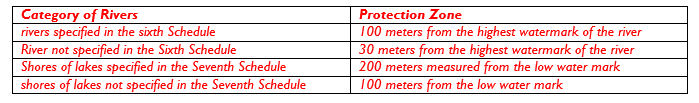
Source: The National Environment (Wetlands, River Banks and Lake Shores Management) Regulations, No. 3/2000 – 6th and 7th Schedules
Instruction 134: Riparian buffer zones should not be harvested for timber, and management should aim to minimize disturbances in them. Degraded riparian buffers should be restored to ensure good water quality.
Instruction 135: Cool temperatures are good for water for human consumption and a good fish habitat. Therefore, keep shade producing vegetation beside stream channels and watering points
¶ Management of Forests for Flood Control
Forest soils act as sponges and retain water longer than soils under other land uses. Forests hold soil in place by the roots of trees and the associated vegetation, provide additional water storage capacity underground, promote high infiltration rates and ultimately, they minimise erosional sedimentation which has an effect on stream discharge capacity. Tree and forest removal, therefore, increase water discharge and the risk of flooding in rainy seasons and the risk of drought in dry seasons. Reforestation and afforestation have the opposite effect on water quantity. The effects of forest management for flood control are most prominent at the micro level and for short-duration and, therefore, need to be integrated into other soil and water conservation measures.
Instruction 136: The following measures may be applied depending on the forest conditions:
(i) In steep headwater watershed areas, natural vegetation should be kept in place and, if harvested, harvested selectively. This then excludes farming and minimises grazing. Otherwise, strict soil conservation measures must be put in place.
(ii) If fire must be used for management purposes, it must be kept light. Peak water run-off flows become more destructive when they carry large amounts of debris left by fierce fires.
(iii) A lot is achieved through careful logging and road construction practices that minimise soil disturbance.
(iv) Re-vegetation of severely degraded lands restores vegetation in uplands that have been denuded by over exploiting forests. In severe cases, re-vegetation may be combined with mechanical soil conservation measures. To allow the cover to establish, other vegetation types should be established to quickly check soil erosion. In non-reserved forested areas, the locally resident communities should be fully involved in preparation and implementation of management plans.
(v) Forests are effective in minimizing surface erosion for a range of reasons. For example, their canopies, undergrowth, leaf litter and other forest debris reduce the impact of rain drops on bare soils, their porous soils help infiltration thus reducing surface water flows and their root systems help hold soil particles together.
(vi) Forests can also help stabilize slopes and protect them from shallow landslides. Landslide-prone areas should be kept forested (or maintained as woodland or agroforestry/silvo-pastoral systems with high tree densities) to reduce the occurrence and severity of shallow landslides. Tree-harvesting activities in such areas should be light and non-mechanized. Note that although forests can play an important role in soil stabilization, there are cases and sites where they will not prevent or mitigate landslides caused by tectonic movements.
¶ Management of Mountain Forests
Mountain forests have a close association with freshwater as they gather water not only through normal vertical precipitation (rainfall) but also by “water-stripping” the fogs and clouds that move horizontally through them. Mountain forests (sometimes also called fog forests) are, therefore, important for water production. Trees can be planted in strategic cloud and fog locations to maximize water-stripping. Mountain forests show a complex relationship between flora, fauna and soils and their loss is irreversible.
Instruction 137: Given their importance in water production and biodiversity conservation, and their general unsuitability for other uses (for example because of soil limitations and climates that are often unfavourable for agriculture), mountain forests should be maintained as forests and identified in national inventories.
¶ Management of TMFs for Forest Products
The National Forest Plan (NFP) focusses on promoting the development of the products and services which have high contribution towards accelerated national social-economic development including high grade timber, construction and industrial poles, woodfuel, non-timber forest products like rattan, herbal medicine, bee products, fruits, ecotourism, aromatic oils, and water catchment services, among others[12].
Apart from timber and industrial poles, the other products and services come mostly from natural forests (TMFs and OWLs), especially from PAs. It is, therefore, important that natural forests are managed in a responsible manner so that they can continue to provide these products for a long time.
NFA has developed a technical guide to support management of Uganda’s TMFs for timber production in CFRs for the purposes of ensuring sustainable management of production zones of TMFs (NFA, 2006)[13]. The guide goes into more detail regarding production of high-grade timber and provides for participation of forest dependent communities in accessing meaningful benefits from the forests. The Natural Forest Management Strategy has outlined six strategies and 40 actions for CFRs[14].The strategies and actions are presented in Annex 7.
¶ Management of TMFs for Timber Production[15]
Timber production in natural forests will normally be possible mostly in well-stocked TMFs. Since virtually all existing TMFs outside PAs in Uganda are highly degraded or completely depleted, and those in Conservation Areas are not available for harvesting, it will only be possible to produce timber from production zones of TMFs in CFRs. Even here, it will be limited to the few CFRs where it can be demonstrated through EI that they are well stocked (adequate basal area).
Increasing pressure on land is leading to increased demands to release more natural forests (in PAs and outside) for agricultural production. An important factor in countering this pressure is to show that the natural forests are being managed for economically viable production of products and services through conspicuous forest management activities. Thus:
***Instruction 138: Management practices for production zones of natural forests shall demonstrate:
(i) Increasing revenues raised from high quality and well stocked natural forests.
(ii) Development of forest-based small and medium scale enterprises.
(iii) Increasing employment of local people.
(iv) Discouragement of illegal activity by constant presence of staff and licensees in the forest.
It is vital to ensure that the forests are managed in a way that optimizes high quality products and services which are not readily produced from plantations. This calls for affirmative silviculture rather than laisez faire management, which is advocated for in large forest tracts elsewhere in Africa and other regions. Failure to observe this will perpetuate the problem of a forest where selective felling of the best trees and species leads to an ever-increasing proportion of defective trees and species that are cheap on the market.
Instruction 139: The Forest Improvement Management System shall be the main vehicle for managing natural forests in Uganda. Central to this System is EI, ISSMI, and PSPs, which generate information that enables forest managers to use low impact logging techniques.
The Forest Improvement Management System has the following features:
(i) A felling cycle of 30 years, but should the managers want to change, the system is flexible enough to adopt different felling cycles.
(ii) Harvesting is controlled through an Annual allowable cut that varies from forest to forest, but averaging 25-30m3 or basal area of 3-4m2/year or about 1m3/ha/year. The felling series are based on the management plan period of 10 years.
(iii) Each felling series is divided into 10 annual felling coupes, the period of a normal FMP.
(iv) Felling intensity can vary depending on the forest manager’s needs. But intensities will be higher where affirmative silviculture is planned.
(v) Reduced impact logging systems in which the largest machinery permitted in the forest are agricultural tractors or light skidders. Therefore, common harvesting systems include small mobile sawmills or pitsawying.
(vi) It provides for effective monitoring of progress in harvesting at block level.
(vii) Tree felling is done for economic and silvicultural reasons.
(viii) The activities of management inventory, stock survey and diagnostic sampling are integrated into one operation. But sometimes it will be necessary to assess regeneration performance at intervals that are shorter than the felling cycle.
(ix) Cyclic management inventories enable the forest manager to track forest performance.
(x) The physical infrastructure in the forest (block lines & strip lines, corner trenches, block labels) are maintained for after-harvest, in-forest activities.
(xi) It encourages forest management staff to spend quality time in the forest implementing technical activities. In the process, reduced illegal activities becomes a positive impact rather than remaining a focus activity. Consequently, financial and human resources are more efficiently and effectively utilized.
(xii) Provides possibilities for licensing forest dependent communities to harvest sawlogs in small quantities, which they can afford without excluding the larger, more commercial operations.
Instruction 140: The principal operations in the Forest Improvement Management System shall include:
(i) Conduct of a more detailed ESIA than the one done for the whole FMP
(ii) EI (Section 3.4.1) to establish the 10-year felling series, annual felling coupes, and Annual allowable cut
(iii) Forest Management Planning.
(iv) ISSMI (Section 3.4.2) to establish the trees to be harvested, those to be reserved for seed, and those to be allowed to grow for harvesting during the next felling cycle tree.
(v) Timber harvesting following the ISSMI tree maps and list of stock trees to be harvested (Section 3.4.2).
(vi) Assessment of natural regeneration (Section 3.4.7) to establish the actions that should be done.
(vii) Carrying out actions that are necessary for development of a good future crop (e.g. climber cutting, felling damage repair, spot planting or only monitoring regeneration performance)
¶ Management Cycle for Timber Production in Natural Forests
Instruction 141: On the basis of the Forest Improvement Management System the timber harvesting cycle in TMFs shall be 30 years, employing the reduced impact logging system. The cycle is shown in Figure 6. Accordingly:
• Where zoning for biodiversity conservation is desirable, the forest shall be zoned on a map and on the ground
• EI, the Point-Centred Quarter Method (Section 3.4.5 above), or some other method that can produce similar results shall be used in the production forest to establish the products which forest management shall work towards
• The felling cycle for each of the woody products shall be established through research. For timber production in TMFs studies have established a felling cycle of 30 years using a selection felling system[16].
• A FMP shall then be prepared in a participatory manner (Section 7.7.2). The FMP shall show different felling series, annual coupes which should also be clearly identifiable on the ground (compartments, felling coupes, etc)
Figure 6: Timber Harvesting Cycle in the Tropical Moist Forests
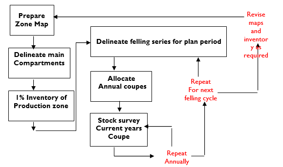
Source: NFA, 2006. A Guide to The Management of Uganda’s Tropical Moist Forests for Timber Production
¶ Management of Other Wooded Lands
The main management objectives of OWLs will normally not include timber (although it should not be excluded), but the products are likely to include charcoal, firewood, and bee products, among others.
¶ Division of the Forest into Compartments
Instruction 142: For ease of management, the forest should be divided into smaller areas known as compartments. To divide the forest into compartments:
a) As much as possible, physical features like roads/paths, streams, valleys, and ridges, shall be used to form natural divisions. Otherwise, other relatively permanent features may be used, e.g. areas characterised by a dominant vegetation type. In such cases, the compartments shall be delineated by cut lines.
b) A general guide for compartment size is 100ha, but smaller or larger sizes may be adopted depending on the size of the forest, variability in terms of physical and vegetation features, ease of access, etc.
¶ Inventory of growing stock
This has been described in Section 3.5.5 above and Annex 6
¶ Development Towards a Closed Natural Forest
Forest Department experiences from the 1950s indicate that most areas had been prevented from developing to closed natural forest (e.g. Kitigo Block in Budongo CFR) because of fires. Many of these areas stop at the fire climax but if fire is excluded, they can develop to closed natural forests over time. This development can be assisted by enrichment planting as was demonstrated in Matiri and Opit CFRs (Petero Karani, 2006[17]).
Experience has shown, however, that the quickest means of getting THF colonisation is to establish mixed hardwood plantations of indigenous species first, and THF species will invade the plantation as soon as the grass has been suppressed. This has been the case in Kibale Forest, areas of Matiri CFR, and Namaganda Hill in Mabira CFR.
Instruction 143: Where it is desirable, especially for purposes of biodiversity conservation and other High Conservation Values, OWLs shall be managed in a way that facilitates their development towards closed forest. Constant fires and grazing (often acting together) are the commonest factors that prevent an area from developing into a closed forest. Therefore, where this is a management objective, management activities shall include protection from fires and grazing.
However, complete protection from fires might be difficult over the medium to long term. And yet if protection is successful for only a few years, a substantial amount of dry grass and leaves (fuel) accumulates, and thus an accidental fire entering that area can be very destructive.
Instruction 144: To prevent such unfortunate accidents, early controlled burning should be done periodically to burn off the grass/ leaves before they can accumulate to dangerous flammable levels should a fire break out. Controlled burning shall take into account the following considerations:
• All neighbours to the area to be burnt should be given adequate notice of the exercise
• Firelines should be cleared around the area to prevent fire from getting out of control
• Adequately trained personnel shall be deployed in sensitive areas like settlements and plantations
• The windward sides of hills normally dry out earlier than the leeward sides
• Areas with a large accumulation of dead material will burn earlier and more fiercely than those with less dead material
• Grass growing on shallow soils will normally dry out and be ready for burning earlier than grasses on deep soils
• Fire moves more quickly uphill than downhill. Therefore, in the earlier days of the controlled burning exercise, when the grass still retains its green, it is advisable to start burning uphill, but later, when the grass is drier, burning can start on the upper slope in order to avoid the fire getting out of control
• Burning should start around mid-day early in the burning season, and progressively start earlier as the activity moves into the drier period.
¶ Managed Charcoal Production in Other Wooded Lands
Instruction 145: For most OWLs, charcoal burning goes on in an uncontrolled manner, and therefore the owners do not get much income from the operation. In order to bring charcoal burning under control, the following broad procedure should be followed:
a) Convene a meeting with the local people to inform them of what you are going to do. During the meeting, discuss:
• The people to be authorised to burn the charcoal
• What they must do or not do to ensure successful re-growth (fire protection, exclusion of grazing, etc.)
• Availability of seasonal contracts for carrying out activities like planting, patrolling, firelines, etc
• Any other matter of concern to the people
b) Divide the area into compartments using physical features as described in section 3.5.4.1 above, remembering that you will be back in this compartment in 10-15 years’ time. If the compartment is too large to be harvested by one authorized entity in one year, divide it into smaller blocks which you can allocate to different charcoal burners.
c) Carry out a reconnaissance of each compartment to determine the degree and quality of stocking of timber and other trees. The Point-Centred Quarter Method outlined in section 3.5.5 above is particularly good for this purpose.
d) Do not burn charcoal in a compartment with stocking of at least 18 trees/ha (10 cm + dbh) of good timber species. Such a compartment should be managed for woodland improvement (protection from fire and grazing, assisted regeneration, liberation tending of seedlings and saplings).
e) For the remaining compartments, decide on the order in which you will carry out charcoal burning (felling series). The aim is to move from one compartment to another in an organized manner so that by the time you complete the cycle and come back to the first one, the coppices will have grown to charcoal producing size.
f) In the compartment to be harvested for charcoal, mark all good quality timber trees so that they are not burnt into charcoal (e.g. Mvule, mugavu, nkalati) together with the other trees
g) Make sure you observe the legal requirements for protected zones as described under section 3.5.3 above
h) Put in place measures to protect the area from grazing and fires. The measures include:
• firelines towards the end of the dry season;
• patrols against grazing and fires;
• setting light fires through the area to avoid accumulation of dry grass that would result in hot fires in case of accidental fires; and
• where possible fencing off the area
i) Start harvesting the compartment/ small block by systematically clear-cutting from one side to another, but do not cut the good timber species as you progress.
j) At the onset of the next rains, examine the harvested area to assess the degree of re-growth (natural and coppices) with a view to filling in with more charcoal or timber producing seedlings. Diagnostic sampling tools should be applied for this.
k) From time to time, monitor progress of the re-growth, liberating it from climber tangles where necessary.
¶ Management for Firewood Production
Instruction 146: Generally, the process described for charcoal should also be followed for firewood production. It must be noted that firewood from natural forests does not fetch good money because in most cases, the market is limited to comparatively short distances from the forest if the trader is to make a profit. This shall be taken into account when a decision to manage the area for firewood is being taken.
¶ Management for Other Forest Products and Services
Instruction 147: Other forest products in this case include rattan canes, wild coffee, Gum Arabic, Shea Butter nuts, Prunus bark, honey, and crafts, among others. For most of these, there are no specific formal practices which have been developed so far. As the practices are developed, they shall be added to the manuals and field tools.
¶ Management of Dual Management Areas
Dual Management Areas are sections of FRs that are also gazetted as part of wildlife conservation areas. During the zoning of conservation areas in FRs, the Forestry Department decided that the Dual Management Areas shall be managed as Strict Nature Reserves or Buffer Zones, allowing only non-harvesting activities.
Instruction 148: Dual Management Areas shall continue to be managed as Strict Nature Reserves or Buffer Zones in collaboration with UWA. Details of how the collaborative actions at the FMU will work shall be discussed with UWA and included in the Memorandum of Understanding between the two institutions (Section 9.2.6).
¶ Management of Forests for High Conservation Values
High Conservation Values (HCVs) are defined as biological, ecological, social or cultural values of outstanding significance at national, or regional or international levels[18]. Forestlands which have these values need to be managed well in order to maintain or enhance them. Example of management actions that can be implemented in the HCVs are outlined below.
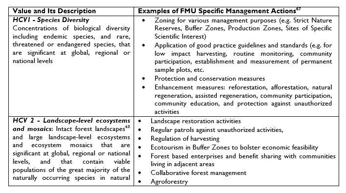
The methods for managing HCV forests include identification, assessment, management strategies, implementation, monitoring, and then revisions of management strategies in line with monitoring results. (FSC, 2017 ibid). FSC has issued a detailed procedure for management of HCVs[23], and Annex I of the NFSS presents the HCV Framework for Uganda which domesticates the HCVs.
Instruction 149: The Ministry responsible for forestry shall regularly review (at least once every five years) the NFSS HCV framework in Annex I of the NFSS, using stakeholder participation methods, in line with the FSC Guidance for Developing National High Conservation Value Frameworks[24]. To this end the Ministry shall domesticate the FSC Guidance so that FPs can easily use it.
Instruction 150: FPs at FMU level shall identify HCVs that are applicable to their areas, and manage them in line with the FSC High Conservation Value Guidance for Forest Managers, and the provisions in the HCV Framework in Annex I of the NFSS. To this end, actions to manage the HCV forest areas shall be identified and included in the FMP, and subsequently, the AWPs.
¶ Management of Forest Plantations
This section deals with management of commercial timber[25] plantations and woodlots for small poles and fuelwood. The practices for growing the common species (pines and eucalypts) on a commercial scale have been described in detail in Jacovelli, et al, 2010[26], and for the small scale community tree growers the practices have been described in Sawlog Production Grant Scheme, 2011[27]. Practices for growing the other tree species are presented in Section 3.5.7 below. Jacovelli et al point out that production of fast growing and high yielding tree crops requires:
• Advance planning and budgeting
• Good matching of species to the sites
• Adequate and timely land preparation so that planting can be done early during the rainy season
• Use of improved seed and high-quality planting materials
• Good weeding before and after planting
• Using the correct spacing
• Timeliness in, and quality of planting and weeding
• Replacement of dead seedlings within the same planting season
• Effective protection from animals and fires
• Effective control of farmers if agricultural crops are grown among young trees
• Monitoring for pests & diseases
• Carrying out the other tending operations (e.g. thinning and pruning for timber) in a correct and timely manner
• Avoiding conflicts with neighbouring communities
Instruction 151: The Tree Planting Guidelines should be followed in growing timber plantations. The Guidelines shall be revised by FSSD periodically as new information emerges from experience and research. The Community Tree Planting Guideline prepared by the Sawlog Production Grant Scheme meets the needs. For the small woodlot growing by communities,
¶ Management of Coppices
The content in this section is adapted from:
• Sawlog Production Grant Scheme, 2005.Plantation Guidelines, No. 21. Sept 2005: Managing Eucalyptus Coppice; and
• Liz Hamilton, Colac, 2000. Managing Coppice in Eucalypt Plantations, June 2000: State of Victoria, Department of Primary Industries
¶ Introduction
Eucalypts has the ability to regrow from cut stumps (coppicing). Coppice management involves selection of suitable stems from this regrowth and the removal of all the others. Coppicing allows the grower to have a second crop without replanting. Only plantations that have not been thinned can be coppiced so that there are enough strong stools to regrow. Hence only stands grown for fuelwood and poles can be coppiced profitably. The ability of eucalypts to coppice declines with age. The larger more vigorous stumps of up to about 30 cm diameter, and from young trees tend to coppice best. Older stumps often fail to coppice.
The cut stump will normally put out many new shoots within a few weeks of being cut. If all of these shoots are left to grow, the stump develops into a bush crowded with multiple shoots. So it is necessary to choose specific stems according to their size and position on the stool and to remove the rest. This allows the remaining shoots to grow well and with a good form, giving the best yield.
Generally, planted or direct seeded plantations can be satisfactorily coppiced many times over. However, not all cut stumps produce good coppices, and over a number of rotations there will be a progressive decline in the number of live stumps which are able to coppice. From the first coppice, the rate of shoot growth from the rootstock can be expected to be around 10-20% faster than that of the original trees. However, the vigour of the coppice from subsequent crops tends to decline. Hence, it may be better to re-plant the site with seedlings after 3 or 4 rotations.
However, it is important to note that not all tree species will coppice after being cut. Some species which coppice include Calliandra calothyrsus, Cassia siamea, Cassia spectabilis, Eucalyptus spp., Leucaena leucocephala, and Markhamia lutea, among others. Certain species coppice well when young but may not do so if cut at maturity. Examples these species are Casuarina spp., Grevillea robusta, Sesbania sesban and some Albizia spp.
¶ Procedure for Coppicing
Instruction 152: To achieve the best possible results from coppicing, tree felling should observe the following:
(i) Trees should be cut at a slight angle to allow water to easily flow off the stump, and thus prevent decay.
(ii) Trees should be cut as low to the ground as practical. Coppice growth on high stumps tends to be weak and is more likely to be snapped off in strong winds. Coppice shoots originating near ground level will eventually develop into trees almost as well rooted as those of seedling origin. Therefore, aim for a stump height of no more than 15 cm.
(iii) Felling shall be done with a bowsaw or chainsaw. Felling with an axe damages the bark where the coppice grows from
(iv) Felling shall be done in blocks so that the coppices in one block can shoot at the same stage. Felling at random results in some stumps coppicing under shade and not developing, and also when the other trees are felled they damage the coppice.
(v) All felling debris shall be removed from the stumps
(vi) Care should be taken not to damage the stumps by driving over them or knocking them with poles.
Instruction 153: Dense coppice shoots usually appear within a few weeks of the tree being felled. Therefore, it is important to take stock of the stumps which are coppicing successfully. A general guide is that if less than 75% of the stumps are coppicing, replanting should be objectively considered, if the trees are being grown as a business.
Instruction 154: To optimise wood production on the most vigorous and healthiest stems, the number of stems should be thinned progressively:
a) The first reduction should be carried out when the dominant shoot height is 3 to 4m. 2 to 3 stems should be retained per stool.
o The selected stems should be dominant, reasonably straight, firmly attached (preferably from low down on the stool) and well-spaced out around the stool. This reduces the likelihood of a strong wind breaking off all the stems.
o The unwanted stems and other regrowth from around the stool must be cut as close to the stool as possible without damaging the selected stems.
b) The second reduction should be carried out when the dominant shoot height is 7 to 8m.
o Generally one stem should be left per stump but 2 stems may be left on the large stools adjacent to gaps or dead stumps. This is to maintain the stand at the original number of stems per hectare. The stems should also be similar in height so that the stand is uniform.
o 2 or 3 stems may be left along the edge of the stand (along roads and fire breaks). These stools receive more light and water than those inside the plantation and can thus support more stems.
c) Both the 1st and 2nd reduction operations create a lot of trash, which soon constitutes a considerable fire hazard. Hence the trash should be stacked tightly in every 5th row, with gaps 5m wide along each row to allow access. Also no trash or trash line should come closer than 5m to the edge of the stand.
d) As with any young trees, the young coppice needs to be protected from animals and fires. Insect attack should also be carefully monitored in the young coppice especially over the first 3 years.
¶ Silviculture of Selected Tree Species, Other Than Pines and Eucalypts
This section provides guidance on the practices which FPs may use to grow species that meet their tree growing objectives. The practices for Tectona grandis (teak), Gmelina arborea, Maesopsis eminii, Markamia lutea, Khaya grandifoliola, Khaya senegalensis, Melia Volkensii, and Melia Azedrach are summarized in Annex 8. However, there is still need for research in the growing practices in specific areas and management regimes.
Instruction 155: The practices described in Annex 8 should be used with a view to adapting them to the specific growing conditions (ecological and social).
Instruction 156: Studies shall be undertaken by government FMIs to update these practices as experience and knowledge emerges. Likewise, as demand for other species grows, the list of species shall continue to be updated.
¶ Tree Pests and Diseases
¶ Common Pests and Diseases
The pests and diseases which are common for the main timber plantation species in Uganda are presented in Table 7.
Table 7: Common Pests and Diseases in the Main Timber Plantation Species
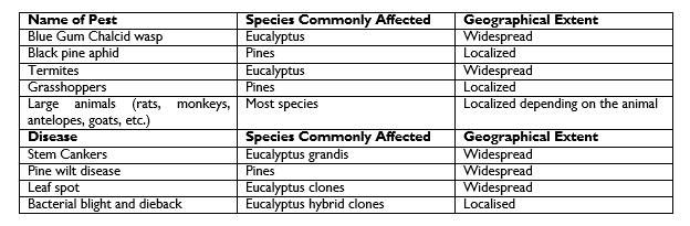
Source: Jacovelli, et al, 2004: Tree Planting Guidelines for Uganda. Sawlog Production Grant Scheme
¶ Managing Forest Pests, Diseases and Damage
Section 36 obliges the Minister, NFA and District Council to notify the public about any pests and diseases that are dangerous to forests and forest products and to prescribe measures for control and eradication of the same. Regulations 50 – 58 provide for management of pests and diseases in forests and forest products. For this to happen FPs need to know how to recognise common pests and diseases and report them accordingly.
In recent times, Uganda, has experienced pests and diseases, especially in the single species tree plantations that have led to economic losses to tree growers. Prevalence of pests and diseases is expected to increase with climate change. It is therefore important that FPs can recognize and control the pests before they can cause widespread damage to forests and the products therefrom.
In the Field Guide for Recognition, Identification and Management of Pests and Diseases of Commercial Tree Species in Uganda, NaFORRI has described methods which can be used to identify and manage pests and diseases of commercial plantation trees. The Guide[28] has also outlined the procedures which can be followed by FPs if there is an outbreak of a pest or disease.
The insects and diseases have been categorised as defoliators, sap suckers, gall forming insect pests, shoot boring insect pests, stem boring and cutting insect pests, and root feeders. For each of these categories, the Guide goes in more detail examples of common insect pests, where they have been reported in Uganda, the hosts (tree species commonly attacked), description of the insect (how to recognise the insect), symptoms of attack, the damage they cause, and the control/ management measures.
The Guide also provides guidance on how to recognise diseases that commonly attack trees, especially in plantations, and how to control/ manage them.
Instruction 157: All FPs, especially at FMU level, shall be responsible for the prompt reporting of pests and diseases and other damage in the course of their work, using the guidelines from time to time issued by NaFORRI. All entomological and mycological reports and specimens shall be sent to NaFORRI, with copies to the FMI Headquarters using the report format below.
Name of collector: ………………………………………………..
Company/ Institution …………………………………………….
Physical Address: ………………………………………………..
Telephone no: ………………... Email: …………………………………..
Location where disease/pest is occurring and dates
GPS location: ………………………………………………………….
Village: ……………………….. Parish: …………………………………
Sub-county County ………………………………… District …………………………………….
Estate/ Forest: ………………………………………….. Compartment no: ………………………
Soil type: …………………………………………………………………
Date sample collected: ………………………… Date sample dispatched: ………………………
Type of sample
Soil Twigs …………….. Stems Water …………… Roots Insects ……………………
Leaves/needles ………. Seedlings/cuttings ………………… Other ……………..
Pest/disease description and history
(i) Tree species affected ------------------------------------------------------------------------
(v) Additional information (e.g. on control actions taken, etc.), if any:
…………………………………………………………………………………………………………………………………………………………………………………………………………………………………………………………………………………………………………………………………………………………………………………………………………………………………………………….
Name of Collector ……………………………………. Signature …………………………………..
Title …………………………………………………………………………..
Instruction 158: Collection and packing of insect specimens shall be handled as follows:
(i) Beetles – Place specimen in test tube or bottle and add spirit such as Ethanol (80%), pack in specimen tubes with most of the spirit poured off; if possible, seal the corks with wax.
(ii) Moths, flies, wasps - kill by fumigation with cyanide or, in emergency, petrol vapour. Pack dry in paper envelopes and include some naphthalene (moth balls) crystals.
(iii) Larvae - in Spirit. If possible, gently boil in water and allow to cool first.
(iv) Wood samples with living larvae - pack in tin or galvanised iron containers for reference.
(v) Collection and packing of fungal specimens shall include:
• Wood samples with mycelium - allow to dry on the surface before packing in wooden or metal boxes. The samples shall be wedged or enclosed in shavings to prevent movement in transit.
• Fruit bodies - dry slowly (not in direct sunshine) before packing in soft material enclosed in box. If possible, send the fruit body still attached to the host.
(vi) If it is not possible to get the chemicals and materials mentioned above, consult NaFORRI.
¶ Integrated Pest Management
Tree pests and diseases are limiting factors in tree nurseries and forests and should therefore be controlled well before they can cause economic damage. The most effective way to deal with forest pests is applying integrated pest management. Integrated pest management involves applying a combination of control options that include preventive, observational and suppressive measures to manage the pests. In applying integrated pest management, non-chemical methods such as cultural, physical and biological control methods shall be given priority but use of chemicals may be preferred as an alternative in severe cases where the pests can only be economically brought under control using pesticides. Refer to the Guideline for Tree Nursery Management for details on pests and disease management[29].
Many pests and diseases can be prevented when species are correctly matched to the sites where they are grown. This avoids stress, which weakens the resistance of the trees. Secondly the pests and diseases can be avoided by carrying out proper cultural operations like weeding, avoiding water logging, etc. Nevertheless, when symptoms of pest or disease attack are first observed (e.g. unexplained death of a tree or groups of trees, swellings on the stem, exudates, dieback, unexplained growth defects, etc.) by the tree grower, it is advisable to seek professional advice from the National Forest Resources Research Institute.
Instruction 159: FPs shall, as a priority, show commitment to reduction and eventual elimination of chemical usage and adoption of integrated pest management practices due to disadvantages associated with chemicals. The integrated pest management methods will include[30]
• Preventive silvicultural measures – which include use of healthy quality planting materials (free of pests and disease); raising healthy seedlings which are vigorous; maintaining a clean nursery environment that reduces the risk of pests and diseases;
• Monitoring through regular observations to identify any signs of pests, such as termites, ants, cutworms, or diseases (fungal, viral and bacterial);
• Mechanical control, which involves physical removal of the pests e.g. digging up anthills;
• Application of organic pesticides and fungicides (Section 3.5.8 below);
Instruction 160: The first line of defence against pests and diseases of planted trees shall be to match the species to the ecological conditions of the site where it is proposed for planting. If the two match, then the second line of defence is to effectively carry out all the appropriate silvicultural and tending operations. This way the plants will be provided with growth conditions that do not stress them and thus weaken their natural ability to resist pests and diseases. Nevertheless, when the pest or disease is first noticed, it should be reported to the Entomology Section at NaFORRI for a more focused assessment.
¶ Use of Chemicals to Control Pests and Diseases
Where non-chemical methods fail to work, chemical pesticides are often used. A wide range of chemicals are used to suppress weeds or prevent/ treat pests and diseases. The chemicals work through their toxic properties, but if they are not used properly, they may also be harmful to people, wildlife, and the environment in general.
Instruction 161: The pesticides used shall not be categorized as highly hazardous or hazardous pesticides by the Forest Stewardship Council A.C (FSC Pesticides Policy, 2019[31]). They should also not be listed in Schedule 8 of the National Environment Management Act, 2019[32]. If chemicals are used, then forest workers must be properly trained, should wear the prescribed PPE during spraying operations, and adhere to environmental precautions.
Instruction 162: Many of the chemicals used in forestry work may be toxic to human beings e.g. insecticides, fungicides, herbicides and preservatives. It is important for both FPs and workers to ensure safety against the application of such materials. In particular, the FP shall provide hands-on training of the workers and assess their competence in the proper use of equipment and application of chemicals. When using chemicals, workers must take into consideration the following safety rules:
(i) Use only under the supervision of a responsible person.
(ii) Follow the manufacturer’s instructions closely.
(iii) Wear coveralls and rubber gloves or barrier cream. If applying or mixing powders, a face mask or goggles is necessary.
(iv) Wash off using soap immediately any chemical falls on the skin.
(v) Wash thoroughly using soap after using toxic chemicals, and before eating or smoking.
(vi) Destroy or render unusable all chemical containers and do not let them be used for carrying drinking water.
(vii) Keep all chemicals in a safe place and under lock and key.
(viii) Members of the public must be warned if they are likely to visit an area where toxic chemicals have been used. Do not use toxic chemicals where domestic animals are likely to wander, or near water supplies.
Instruction 163: The checklist below should guide the FP in order to achieve effectiveness and efficiency in the use of chemicals[33]:
(i) Identify the target weeds so that the correct herbicide and dosages can be used
(ii) Buy only good quality spraying pumps, whose spare parts can easily be obtained within the country
(iii) Buy chemicals from reputable dealers and only accept sealed containers with the original manufacturer’s label on.
(iv) Read the manufacturer’s prescriptions on the label carefully before using the chemical
(v) Ensure the correct pump nozzles are used for the job in hand
(vi) Time the operation so that the target weed is at the right stage of development for cost-effective treatment
(vii) If pre-plant spraying with Glyphosate, time the operation so the spraying operation is carried out as close as possible to when the site will be planted
(viii) Regularly calibrate equipment and spend time training a spray-team
(ix) Spray operators must wear coveralls, gumboots and other appropriate protective equipment at all times
(x) The pumps must be regularly inspected for leaks and to ensure that they are in good working order
(xi) Spraying must only be carried out under favourable weather conditions.
(xii) Spray operators must be provided with clean water and soap for washing with on site
(xiii) The herbicide containers must be properly (and securely) stored, and empty ones punctured and disposed of properly to prevent re-use for other purposes
(xiv) Any undesirable effects observed during or after the application of herbicide should be appropriately mitigated
(xv) The application of chemicals must avoid the risk of contaminating ground or surface water
(xvi) Chemicals must be applied only at the recommended rates for the target pest/ weed.
(xvii) Chemicals should not be transported to the field in bulk to avoid dangers of accidents.
(xviii) Avoid spraying during windy conditions to avoid chemical drift from the application point. This is particularly important when spraying near special conservation areas.
Instruction 164: Records of chemical use shall be maintained, including training, types of chemical and their rates of application, safety issues that arise and how they are dealt with, among others
More detail on arrangements for field operations are given in the SPGS Community Tree Planting Guidelines of Uganda quoted above, Chapter 12, which deals with safe use of herbicides. The chapter includes, among others:
• Planning for spraying
• Rates of use of chemicals
• Equipment and tools used
• Safety and operational matters
• Training of spraying gangs
• Disposal of empty containers
• Calibration of knapsacks to determine how much chemical and how much total solution to use to achieve the desired control effect
¶ Wind Damage
Instruction 165: Wind damage involving more than 0.1 ha shall be reported on the Fire Report Form using such headings as are applicable. Additional information on soil texture and depth, rooting depth, density of crop, pruned height, health and vigour of the crop etc. shall be given.
¶ Control of Termites
The aforesaid notwithstanding, control of termites is described below in more detail because termites are the most widespread pests in planted trees in Uganda. Termites also attack a wide range of species. The details below have been extracted from Tree Planting Guidelines for Uganda, by Jacovelli, et al, 2004.
Instruction 166: Where termite infestation is an obvious threat, the following management practices are the first line of defence:
• Use healthy and vigorous planting stock
• Plant the seedlings as early as possible in the rainy season to encourage vigorous growth
• Ensure seedlings are well watered immediately before planting out to limit stress immediately after planting
• Use species or provenances that are resistant to termites
• The above measures may be supplemented by digging up the mounds and destroying the queen, where the termites are mound-forming.
Fungus-growing termites are the most destructive. They prefer to eat dead plant material. Their attacks are thought to be related to soils with low organic matter content. This is because such soils do not contain enough food for termites to live on, and thus, they resort to feeding on living plant material.
Instruction 167: Compost or well-rotted green manure may be added to the soil to increase the organic matter in the soil. However, in some cases, the organic matter might attract termites and when the organic matter is finished, the termites might attack the trees.
Indigenous plant species are more resistant than exotics. Table 8 gives a number of tree species and shrubs that have proved to be termite resistant, and the plant parts that can be used for preventing termite attack.
Table 8: Some Plants with Termite Control Properties
Source: HDRA - the organic organisation: https://www.infonet-biovision.org/sites/default/files/490.hdra_termite.pdf
Kiwusu, et al (2004)[34] has also described some of the non-chemical methods which are used by farmers in agroforestry systems. They include, among others
• Ash mixed with cow urine
• Red pepper mixed with water
• Melia azedrach leaves mixed with water and poured into the anthill
• Directing surface runoff into the anthill
• Pounded tobacco mixed in water, cow urine and pepper
• Ash and cassia leaves mixed into water
• Hot crude waragi distillate poured into anthills
Instruction 168: The termite control properties listed above should be tested at every FMU through research carried out by field staff of FMIs and the findings recorded and submitted to NaFORRI Entomology Section for further screening and validation
Instruction 169: Where there are terrestrial termites (termites which keep on moving around the field), drenching the planting pits or spraying the planted tree down to the root collar with a termiticide may be done. Systemic chemicals like imidacloprid are desirable for this purpose because they are taken up by the plant and can provide protection for a much longer time
¶ Agroforestry and other Farm Forestry Systems
Agroforestry is a farming system where trees are planted as part and parcel of the farming landscape. The concept of Agroforestry is based on development of an interface between agriculture and forestry, and the rationale lies in optimizing production based on the interactions between the components and their physical environment. This would lead to a higher sum total and more diversified and /or sustainable production than from a monoculture of agriculture or forestry alone. Since agroforestry involves mixing of trees with agricultural crops and/ or livestock, it is mostly applicable on lands that are outside PAs. In agroforestry/ farm forestry systems, suitable trees are planted to provide shade to agricultural crops like coffee, cocoa, banana plantations, or judiciously interplanted with crops, on the edge of a farm, or in a mixture with other crops to provide various ecosystem goods like fuelwood, poles, fruit, food, bark cloth, fodder, wood for construction of shelters, craft materials, timber for furniture and construction, and medicine, among other products. Equally important are the following facts in agroforestry:
• Trees provide shade in homesteads and cattle farms
• In most cultures, certain species of trees are recognised as de facto boundary markers (e.g Ficus natalensis, Dracaena fragrans)
• Trees are often grown deliberately for generating income, and thus employment
• Trees provide essential nutrients like nitrogen on farms, and recycle deep nutrients for crop use, thus sustaining agricultural production
• Suitable tree species can be grown as windbreaks and shelterbelts
• Trees absorb CO2, and other harmful gases, removing and storing them while releasing oxygen back into the air. Trees soak up CO2 naturally, creating cleaner, healthier air for humans and mitigating against greenhouse gases.
• Tree root systems and leaf cover on the ground filter out pollutants, thus cleaning the water which enters into water bodies
• Tree growing along river banks and around water reservoirs helps to cool the water during hot dry weather
• Trees reduce surface runoff, thus allowing the water to flow down the trunks and into the earth below the tree, consequently recharging groundwater supplies. A mature evergreen tree can intercept more than 15,000 litres of water every year[35].
• Humans feel a calming effect from being near trees. The serenity we feel can significantly reduce stress, fatigue, and even decrease recovery time from surgery and illness (Jiang et al., 2014).
• Trees harbour wildlife, and thus promote recreation on the farm while enhancing biodiversity conservation.
• Risk management- Agroforestry involves a mixture of species at times maturing at different rates, demanding different growing conditions, and producing a variety of products with different market niches. These can substitute or supplement each other in case of seasonal climatic or market failures Policy Statement No. 6 of the Forestry Policy commits government to promote and support farm forestry in order to boost land productivity, increase farm incomes, alleviate pressures on natural forests and improve food security. To this end, Government has committed itself to provide advisory services that support farmers, communities, organisations and entrepreneurs in the conservation and sustainable management of forests, and more specifically, in the development of farm forestry. In pursuit of the Forestry Policy, the National Forest Plan encourages private landowners to participate in tree farming, making farm forestry/ agroforestry relevant in augmenting tree cover. Unfortunately, the policy provisions have remained largely on paper, with no visible effort of central or LGs to implement them.
Instruction 170: Government FMIs shall work within the policy framework to plan for, and implement the following policy strategies:
• Strengthen farmer community institutions for better communication and collaboration in the development of farm forestry.
• Build the capacity of farmers to integrate trees into all farming systems.
• Disseminate farm forestry advice through decentralised, farmer-driven service delivery arrangements.
• Develop the capacity of NGOs, CBOs and private contractors, as well as government agencies, to provide farm forestry advice and training.
• Create awareness of the ownership of planted trees to provide clear incentives and security for individuals to undertake on-farm tree-growing.
• Intensify participatory research on farm forestry technologies in all agro-ecological zones, and promote farmer innovators.
• Support the private sector to establish and manage commercial tree nurseries to support farm forestry.
• Support the development of high-quality tree seed and planting stock.
• Integrate agroforestry into school curricula and adult literacy programmes.
• Support the domestication of endangered, vulnerable, endemic or rare wild tree species and promote their conservation on farm.
• Promote the use of indigenous species and indigenous knowledge in farm forestry
Trees in agroforestry/ farm forestry systems can be grown in a variety of configurations. A few are described below. Before a decision to support farmers is taken, it is important that the farmers specify the reasons why they want to grow the trees so that a suitable configuration is adopted on the basis of tree growing objective, ecology of the area, species compatibility with the agricultural commodity, social acceptance, etc.
Instruction 171: Tree growing objectives usually embrace the aspects of restoration of the forest cover, income generation, and people’s wellbeing. Based on these aspects, a farmer may choose to grow trees for any of the products and services mentioned above. Accordingly, trees in agroforestry/ farm forestry systems may be grown in a variety of configurations. Some of them are described below.
¶ Woodlots and Small Forest Management Units
Uganda’s SPGS sets the minimum size of a commercial timber plantation at 20 hectares. This includes smaller forests which are owned by individuals but managed within a framework of a community based organisation. On the other hand FSC defines small FMUs as those units which are 100ha or smaller in area, but they could be up to 1,000 ha in area if the national standards setting entity has proposed the area with the approval of a wide range of national stakeholders[36]. In line with the FSC definition, the NFSS defines small FMUs as being up to 1,000 ha, without setting a lower limit.
On the other hand, the Uganda Forestry Nature Conservation Master Plan, 2002, classifies Forest Reserves as follows[37]
In view of these different perceptions of a “small FMU”, these SFPs have adopted the following definitions, regardless of whether the FMU is a plantation or a natural forest:
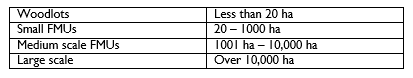
This size of the “woodlot” takes care of trees grown by individuals and families for subsistence and other purposes (e.g. for provision of fuelwood and poles for domestic uses, protection of local community well, a grove of fruit trees, etc.). There may or may not be some income from the woodlot. Woodlots are particularly suitable as family forests because they do not require a lot of money to start and manage, and are compatible with the generally small parcels of land owned by families in the rural areas, where land holding averages 1.6 – 2.8 hectares in the South and 3.2 hectares in the North[38]
The practices for managing woodlots and small FMUs are similar to those used in establishing and managing plantations described in Section 3.6.11, TMFs in Sections 3.6.7, and OWLs in Section 3.6.8). However, because of the size of woodlots and small FMUs, the economic, environmental, and social risks associated with management activities are generally lower than those involved in managing the larger forests (e.g. they use hand tools, limited use of fertilizers and pesticides, etc.), management demands are normally less rigorous than the medium to large FMUs.
Instruction 172: The indicators in the NFSS shall guide the management of small-scale forests/ woodlots for purposes of RFM. Where low management rigour is advised in the NFSS, the indicators are tagged “For LIO and SLIMF[39]”
¶ Trees Along Boundaries
The boundaries may be external, running along the edge of the land owned by the farmer, they may be internal, dividing the land into blocks, or dividing a mixed farm from other multipurpose land uses like agriculture on the same landholding. It is possible to grow the trees in one or more lines along the boundaries, but if the boundaries are long, it will be difficult and uneconomical to protect the trees against fires or browsing by livestock. In addition, the financial benefits would not be that motivating.
Instruction 173: Therefore, to the extent that it is practicable, several lines, or groups of trees in strategic sections of the external boundary which are vulnerable to unauthorised use should be grown. In this way, the land would be protected, and the economic feasibility of growing the trees would be much better (See also Section 3.7.1 on boundary demarcation and maintenance). For PAs, the trees should be grown inside the external boundary, with the outside line of trees marking the boundary line.
Instruction 174: For internal boundaries, the configuration of the trees should be determined according to the subsidiary objectives like providing shade, reducing the speed of wind in the vicinity of farm buildings or forest stations, improvement of quality of water, erosion control, etc.
It is important to understand that a tree seedling, sapling, or young tree (planted or self-sprouted) growing on or close to a property boundary will grow, and spread its crown and roots into the neighbouring property. This may affect crops or other property on the neighbour’s land, and this often causes conflicts among the neighbours. Therefore, before growing a tree on or close to the boundary line, it is critical that the properties of the tree (height, crown width, and spread of root system) when it is full grown are understood.
Instruction 175: In growing the trees along the property boundary, one may choose one or a combination of the following options:
(i) Make sure that the boundary line is well marked so that there is no mistaking where it passes
(ii) A short, narrow crowned tree may be grown closer to the property line than a tall or broad crowned one. For example, if the tree’s crown is expected to reach 5 metres in diameter at maturity, it is advisable to plant it at least 2.5 metres (half of its width) from the neighbor’s property so it stays entirely on your side. On the other hand, if the tree is expected to grow to 30 metres tall, then it’s best to grow it 30 metres from the boundary line
(iii) Do not grow tall trees beneath power lines and communication cables if they are passing along the edge of your property, e.g. in a road reserve. On the other hand, do not grow trees over underground drains, cables, or other underground works. Keep back at least 10m from these.
(iv) Keep back 20m from inhabited buildings or where this isn’t possible use common sense to avoid trees growing too big and close to houses/buildings.
(v) Leave a buffer of at least 30-100 metres along rivers and lakes. Some trees can be planted at wider spacings within this area as long as there is an even balance of light and shade.
(vi) Manage the crowns of trees by pruning or pollarding[40] to restrict crown size and tree height; cut back spreading roots, at least 0.50-1metre from the tree trunk when they reach a height of 2-3 metres. It is also possible to dig a trench (0.3-0.6 m) along the edge of the boundary to check the spread of roots into the neighbour’s land
(vii) Explore the possibility of sharing the trees along the boundary, for example:
• share costs of establishment and management of the trees on either side of the boundary line and share the benefits equitably
• ownership of sections of the boundary where each land owner grows and manages their own trees
¶ Trees Scattered Around the Farm
It is possible to simply scatter trees in the farm (e.g. in crops like coffee or cacao, in the vicinity of farm buildings, and on soil conservation structures). This can be done through leaving naturally growing trees during land clearing for agriculture, or allowing young seedlings to grow. Such trees will also provide shade for livestock, and keep the pasture green for longer periods of time during the hot dry seasons.
Tree species dispersed over crop land may include Albizia spp., Cassia siamea, Commiphora eminii subsp. zimmermanni, Grevillea robusta, Sesbania sesban, Ficus natalensis, Bridelia micrantha, Croton macrostachyus, Cordia abyssinica, Jacaranda mimosifolia (only in high-rainfall areas), Spathodea campanulata, Markhamia lutea, Acacia spp., Combretum spp., Terminalia spp., Piliostigma thonningii, Erythrina abyssinica, Entada abyssinica, Balanites aegyptiaca, Morus spp., Faurea saligna, Ficus natalensis, Grewia spp., Melia volkensii, Moringa oleifera, Psidium guajava, Calliandra calothyrsus, Flemingia macrophylla, and Gliricidia sepium, among others.
Instruction 176: Where natural trees have already been cleared, and natural regeneration is inadequate, new trees should be planted. In such cases, the trees shall be planted in a way that they can be found in future, for tending activities. For this purpose, it is possible to store GPS positions (most smartphones these days can download GPS
applications) for each planting spot, but this is only for the community members who can afford it, and who have the interest to invest in it. If the GPS option is not possible or feasible (e.g. no network coverage), then the trees can be planted in lines where the trees are widely spaced (e.g. at intervals of 20 metres and above, and marked with pegs.
Instruction 177: More than one tree may be planted at each spot, so as to give a chance for at least one tree to outgrow the hazards that arise out of grazing/ browsing, trampling, and fire. It will also be necessary to put structures around the planted trees to protect them from those hazards.
Instruction 178: Under this configuration, the objective of management of the trees to be left or planted on the farm may include:
• Providing shade for the animals and farm workers;
• Creating a cool micro-environment for grass to remain green during the hot dry seasons;
• Providing fruit and vegetables for farm workers and neighbouring forest dependent communities;
• Providing fodder for calves that remain at home during the dry season;
• Firewood and poles to farm use; and
• Eventually providing timber.
¶ Windbreaks Shelterbelts
Windbreaks may be mechanical structures or planted trees which break the wind-flow and reduce wind speed. On the other hand, shelterbelts are rows of trees and shrubs grown for protection of cropland/ pastureland, farm buildings, schools, etc. against wind. Both of them can provide a suitable habitat for wildlife as well as wood products.
The windbreak/shelterbelt is designed so that some of the prevailing wind will go through the trees/shrubs, some of it will be diverted round the sheltering rows of trees, but most of the wind will be forced to raise above the belt, and eventually come down a distance away from the area being sheltered. The shelterbelts can be repeated at intervals if the land being sheltered is large. The structure of the belt takes into account the following key considerations, among others:
• Height of trees (should be variable within the belt)
• Density (should not be too dense so as not to cause whirlwinds on the windward side)
• Species composition (trees, shrubs, long lived and short lived)
• Belt orientation (across the prevailing winds)
Figure 7 shows the Structure of a typical Shelterbelt
Reduction of wind speed on the windward side of the windbreak/ shelter belt results in a modified micro-climate on the sheltered side of the land, leading to better growing conditions for crops and pasture, and a better living environment for homesteads.
Instruction 179: Forestry practitioners shall seek to increase tree cover by helping to establish windbreaks and shelterbelts around forest stations, on farmlands, government buildings, schools, etc. through effective forestry advisory work.
Figure 7: Structure of a Shelterbelt
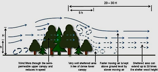
Source: Molla Mekonnen Alemu, Ecological Benefits of Trees as Windbreaks and Shelterbelts, International Journal of Ecosystem, Vol. 6 No. 1, 2016, pp. 10-13. doi: 10.5923/j.ije.20160601.02.
¶ Trees Along River Banks and Around Water Sources
These are vegetation belts where trees are a prominent feature along rivers that pass through the farm, and water sources like dams and ponds within the farm. These belts may be degraded forests or completely stripped of their tree cover, so that water courses and sources are getting polluted or silted. Consequently, it may be necessary to protect degraded forest or stimulate natural regeneration through farmer managed natural regeneration techniques, or enrichment planting. Quite often however, restoration is a mix of protection, controlled use, stimulation of natural regeneration and planting of new trees.
Instruction 180: If the river bank or belt around a water source had been completely stripped of tree cover and other vegetation, then belts of trees, shrubs, and other grassier ground cover vegetation should be re-established, mainly through re-planting and protection. On the other hand, if the vegetation is only degraded, it may be possible to protect the belts from human use and livestock grazing until the land is restored through natural regeneration or assisted regeneration.
¶ Fodder Banks
Fodder banks consist of forage plants established and properly managed in a concentrated unit to provide animal forage. While fodder banks can be utilized all year round, they are usually designed to bridge the forage scarcity of annual dry seasons. Therefore, fodder banks do not normally provide 100% of feed requirements, but rather supplement the available dry-season forage. The common fodder species include Calliandra colathyrsus, Vernonia amagdalina and Morus alba.
Instruction 181: In areas where dry seasons are normally long, FPs working in forestry extension should advise communities to establish fodder banks to supplement any feed that is available for livestock
¶ Home gardens
Home gardens are usually mixed plantings of annual (mainly vegetables and herbs) and tree crops (such as fruit trees and fodder) around dwellings. Women make most of the decisions on management of home gardens and help to conserve many species in small areas while providing a diversity of household nutritional and dietary needs. Home gardens also contribute to improved ecosystem functioning.
¶ Improved fallows
Improved fallows are the deliberate planting of fast-growing species — usually legumes, for rapid replenishment of soil fertility. The shrubs used are usually nitrogen-fixing species or a species that produce more foliage that decomposes rapidly to provide organic material and make more nitrogen and phosphorus available to the integrated agricultural crops. It is always desirable that the shrubs used in improved fallows are fast growing to outcompete weeds, be easy to remove for the next crop and provide wood, forage or other products. Commonly recommended species include Sesbania sesban, Gliricidia sepium and Leucaena leucocephala.
Instruction 182: FPs working in forestry extension shall actively engage communities, with a focus on women, to expand the areas under home gardens and improved fallows
¶ Farmer Managed Natural Regeneration
In farmer managed natural regeneration (FMNR) practices, farmers protect and manage the growth of trees and shrubs that regenerate naturally in their fields. It is an easy, low-cost way for farmers to increase the number of trees in their fields because it does not involve planting of seedlings and all the operations associated with tree planting. Key steps in practicing FMNR are outlined below[41]:
(i) Select species and stumps
• Generate a preferred species list with the community based on required uses of the trees to be regenerated, local species availability, and possible restrictions. When regenerating from tree stumps, base your selection on individual and community goals.
• For each stump, choose a number of the tallest and straightest stems to leave.
• Mark out saplings and poles that are growing naturally
• Where there is bush encroachment, select the desired trees and species to be managed and cut out the rest. When dealing with dense thickets, you may need to make decisions as you go, because many trees will not be accessible until you have removed some of the unwanted bushes.
• Release the desired trees which are entangled by climbers
(ii) Prune and manage
• Remove unwanted stems and side branches, leaving only the strongest and straightest stems.
• Protect the remaining branches, seedlings, and poles from livestock, fire and competing vegetation or weeds.
(iii) Maintain and utilise
• Periodically return to the trees and cull emerging new stems and prune side branches from time to time.
• Eventually the trees can be harvested using the selection silvicultural system
The way these practices are undertaken will depend on what individual land users would like to achieve through FMNR, and how the community has agreed to manage it. FMNR can be successfully combined with other development practices, whether to provide a sustainable foundation of natural resources for further agricultural or environmental initiatives, such as water conservation, or in conjunction with other social or economic development activities, such as disaster risk reduction, water, sanitation and hygiene, savings groups or value chain development. FMNR is integrated with other livelihood options enabling poor communities to let the trees left to grow as this will provide diversified income sources for the farmer.
Instruction 183: FMNR should be encouraged within the farming systems as a technically simple and inexpensive practice in restoration of forest landscapes
For more detailed practical guidance on FMNR, see: Farmer Managed Natural Regeneration (FMNR) Manual on https://fmnrhub.com.au/wp-content/uploads/2019/03/FMNR-Field-anual_DIGITAL_FA.pdf
¶ Trees on Other Vulnerable Sites
Other vulnerable sites on the farms may include:
• Biodiversity “hotspots”, e.g. internationally or nationally threatened species[42];
• Steep slopes which are prone to overgrazing, leading to erosion
• Groves for breeding of rare birds, around wells and springs, etc.
• Reserved species and protected trees (Sections 30 and 31 of the Forestry Act and Schedule 8 of the Forestry Regulations)
Instruction 184: The indicative ecological conditions for different tree species are given in Annex 9. This list shall be updated by FMIs as new information becomes available through research and practice.
¶ Growing Fruit Trees
Growing of fruit trees, whether in an orchard or in a home garden is an important agroforestry activity in Uganda. The manual for Technical Guidelines on Tropical Fruit Tree Management in Ethiopia presents the basic principles of fruit nursery and crop management[43]. The manual presents management practices for the fruit trees that are commonly grown in Uganda, including avocado, mango, papaya, citrus (orange, lemon, mandarine), and guava.
It should be understood that the success or failure of an orchard is largely dependent on how well the propagating and growing of fruit trees has been done in the early stage, therefore proper nursery care is crucial. The methods in the nursery include grafting, cuttings, layering, and propagation from seed. The methods which can be used for specific fruit tree crops are indicated in Table 9[44]
Table 9: Methods for Propagating Some Fruit Trees in the Nursery
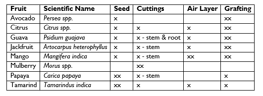
Some of these methods have been described in Section 2.3 and the others have been described by Quentin et al, 2012[45].
Instruction 185: FPs engaged in forestry advisory services shall seek to build their skills in the science and art of propagating fruit tree crops. As more fruit tree crops are demanded the FP shall use their initiative to develop practices for raising them
¶ Establishment and Management of Urban and Peri-Urban Forests and Trees
¶ Urban Areas in General
Urban forests are vegetation systems comprising all woodlands, groups of trees, and individual trees located in urban and peri-urban areas. They include forests, street trees, trees in parks and gardens, and trees in derelict corners. Forests and trees in urban and peri-urban environments, if properly managed, help make urban areas[46]
• safer – by reducing storm water runoff and the impacts of wind and sand storms, mitigating the “heat island”[47] effect, and contributing to the adaptation and mitigation of climate change;
• more pleasant – by providing space for recreation and venues for social and religious events, and ameliorating weather extremes;
• healthier – by improving air quality, providing space for physical exercise, and fostering psychological well-being;
• wealthier – by providing opportunities for the production of food, medicines and wood, and generating economically valuable ecosystem services; and
• more diverse and attractive – by providing natural experiences for urban and peri-urban dwellers, increasing biodiversity, creating diverse landscapes, and maintaining cultural traditions
The Forestry Policy recognises urban and peri-urban forests for their contribution in improving the quality of life in urban areas. This includes provision of:
• Consumables like firewood, food, fodder and poles, especially in the poorer sections of the urban areas,
• Invisible benefits like reduction of air pollution and noise, the control of water runoff and soil erosion
• Enhanced landscape and recreation, thus increasing the value of properties in urban areas
The Policy further recognises that with continued and accelerated urbanisation in the country, the demand for these goods and services will continue to grow. Nevertheless, urban forests and trees are hampered by a number challenges, which include:
• Competition and conflict with other land uses, especially infrastructure and farmland (especially in peri-urban areas)
• The perception that urban and peri-urban forests are obstacles to urban development
• The perception that urban and peri-urban forests pose hazards to urban dwellers (e.g. as havens for criminals)
• A lack of understanding of the benefits of urban and peri-urban forests
• Inadequate legal framework to govern urban forests
• The lack of professionals on the staff of urban authorities, and thus little budget is allocated
In Policy Statement No. 9, Government commits itself to improve the livelihoods and well-being of urban people by supporting urban forestry and improving the urban landscape and environment. Government specifically commits itself to support the private and non-government sectors through provision of incentives to enable them play a major role in the development of urban forestry.
More specifically, Kampala Capital City Authority has enacted a Green Infrastructure Ordinance, 2021, and prepared an Urban Forestry Management Plan to guide forestry development in the City. It is expected the other emerging cities and other Urban Authorities will eventually develop their own legal and planning frameworks to include responsible management of forests and trees in the urban areas.
Instruction 186: In view of these policy, legal, and planning commitments, Government FMIs and Urban Authorities shall give an increased focus in their programmes and budgets to urban forestry in order to effectively implement the following strategic commitments of Government:
• Promote the establishment and maintenance of green belts in urban areas as part of urban land-use planning
• Develop institutional linkages between NFA (there are CFRs in some urban areas), urban authorities, NGOs/CBOs, and the private sector to plan and implement urban forestry developments
• Encourage NGOs, CBOs and the private sector, including women's and youth groups, to plant trees in all urban areas in Uganda, through appropriate education, publicity, incentives, land leases and tree tenure arrangements.
• Promote the planting of road reserves in environmentally and socially strategic road sections through the Ministry responsible for roads (trunk roads) and DLGs (feeder roads).
• Provide technical advice on tree nurseries, guidelines on urban tree growing and management (Annex 10), including site selection criteria and appropriate tree species and sources of seeds.
¶ Management Planning
Instruction 187: Each Urban Authority shall develop a management plan for urban forests. FAO Guidelines on Urban and Peri-Urban Forestry may be used as the starting point for deciding on the management plan objectives and actions. The objectives of the FMP should include some of the following:
(i) Improving human health and well-being
(ii) Adaptation and mitigation of the urban environment and climate change
(iii) Enhancing and safeguarding biodiversity in the urban landscape
(iv) Increasing economic benefits and enhancing the green economy
(v) Overcoming environmental risks associated with urban activities
(vi) Mitigating land and soil degradation
(vii) Improving the quality of watersheds and the associated water
(viii) Strengthening food and nutrition security
(ix) Strengthening wood products security
(x) Safeguarding socio-cultural values
¶ Forest and Tree Configurations
Instruction 188: The forests and trees may be grown in one or more of the following configurations in urban and rural growth centres:
• Forests and woodlands surrounding urban and rural growth centres established and managed to provide goods and services such as wood, fibre, fruit, other non-wood forest products, clean water, recreation and tourism
• Urban parks and gardens with a variety of vegetation cover and at least partly equipped with facilities for leisure and recreation, provision of environmental services.
• Roadside/ avenue trees, small groups of trees, and individual trees in public squares, parking lots, and private housing estates for environmental and aesthetic purposes
• Other green spaces like urban agricultural plots, sports grounds, vacant lands, lawns, river banks, open fields, cemeteries botanical gardens, and compounds of private buildings, among others
¶ Felling of Trees in Built-up Areas
Where trees are growing in high population growth centres, a need will always arise for felling when a tree is dying, or a tree poses a danger to buildings and infrastructure. The circumstances under which the felling of trees in built-up areas is necessary is therefore situation specific. Most circumstances are complex, while some are simple, requiring the basics of directional felling. Felling trees in complex situations can be very dangerous to people living in those areas and nearby buildings. Often the trees are close to buildings and/or the crowns are close to live electrical wires. The tree may have to be felled in the direction that is opposite to the direction of its lean, if it is leaning towards the building that must be protected. There is no tree like another, and the unexpected may happen with devastating consequences. Therefore, the person felling the tree must have much more than basic knowledge and skills of tree felling.
Instruction 189: In order to guide tree felling in built up areas, NFA has prepared a guide which describes the actions to be taken in the felling process[48]. The actions outlined in the Guide should be taken into account when trees in built-up areas are felled. More detail is available in the Best practice Guidelines for Tree Felling prepared by FITEC – Technological Innovations[49].
¶ Growing of Trees Along Avenues and Roadsides
Road construction can concentrate and generate high surface runoff which may lead to adverse effects like erosion, gully formation, waterlogging, silting of water courses, and washing away of crops, especially during the peak rainy seasons. However, some of the negative effects can be remedied through planting trees and other types of vegetation along the roadside, combined with water harvesting, and well planned and directed road infrastructure like drainage channels, and storm water diversion drains.
Tree growing along roadsides can contribute towards restoration of vegetation cover which is denuded as a result of clearing during road construction, and the concentrations of people that tend to be attracted at specific points along the road for purposes of income generating activities like charcoal production, production and selling of agricultural commodities, livestock farming, etc.
Tree growing can lead to benefits like trapping dust from the roads, increased water quality by reducing sediment flow, road beautification, flood control as the trees slow and absorb road runoff, reducing the speed of wind, and improving peoples’ health, among others.
Instruction 190: In growing trees along roadsides and avenues, trees should be grown using the guidelines outlined in Annex 10. The Ministry responsible for forestry shall develop and keep updated the detailed guidelines. Kilongosi, et al[50] is also a very good practical guide[51]
¶ Managing the Risks of Trimming and Removing Trees in Urban Areas[52]
In urban areas and other areas where there are risks to human life and structures/ installations, it will be necessary from time to time to remove dangerous branches, or even whole trees which are over-mature, diseased, or where the tree density has become too high for the objectives of management. The work includes among others lopping[53], pruning[54], trimming, repairing, maintaining and removing amenity trees[55] as well as ground operations like wood chipping, stump grinding[56] and root pruning.
Instruction 191: The following steps should be used to decide what is reasonably practicable to ensure workers and other people are not injured when carrying out tree trimming and removal work
(i) Find out what could cause harm (Figure 8), for example:
• Slipping, tripping and falling
• Manual tasks i.e. lifting, pushing, pulling, repetitive movements, holding machinery
• Contact with energised overhead electric lines or underground services
• Crush injuries, entanglement, cuts and abrasions from the incorrect use or lack of
• Maintenance of machinery e.g. chainsaws, wood chippers and stump grinders
• Being struck by vehicles or mobile plant moving on or working near the work site
• Falling objects
• Punctures and cuts from tree branches
• Allergic reactions to trees and poisonous plants, and
• Biting or stinging hazards including ants, bees, wasps and snakes
(ii) Identify the likelihood of somebody being harmed by the hazard and how serious the harm could be
• Is the tree decayed or dead and unsafe to climb or be attached to?
• Is the species or the particular tree susceptible to branch failure when under load?
• Is the tree stable in the ground?
• Is the crown of the tree leaning heavily in one direction?
• Is the tree suitable to be climbed?
• Are there insects or other animals in the tree that may be a risk to a worker
• Are there utility lines that may be damaged by the tree or its branches?
(iii) Take action to control the risk
• Is it possible that hazards can be completely removed from the workplace?
• Can the work process be designed to remove or reduce the hazard, e.g. use of appropriate technology, re-training?
• Can the hazard be isolated from people, e.g restrict access?
(iv) Check control measures regularly
This ensures that the controls remain effective and that the system is working, subject to changes that may be instituted during the work process
Instruction 192: The Guide to Managing Risks of Tree Trimming and Removal Work referenced above has more practical details on how the risks can be handled. MWE shall adapt this Guide to the urban conditions in Uganda and keep it updated as technology evolves and experiences emerge.
Figure 8: Visual Assessment of Trees
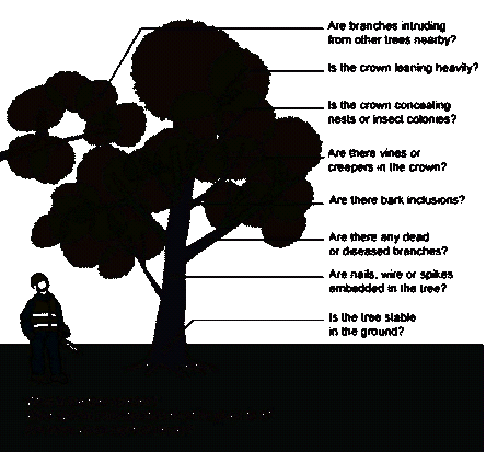
Source: Safe Work Australia, 2016. Guide to Managing Risks of Tree Trimming and Removal Work
¶ Recreation in Forests
Recreation in forests commonly includes ecotourism, camping, picnic sites, or simply walkways in the forest. It may also be possible to design hiking and biking trails that go through the forest and on to the surrounding lands. In some cases, accommodation facilities are constructed in rural areas from where it may not be convenient for the tourists to go back to the town where suitable accommodation can be found. At many ecotourism sites in Uganda, a number of the facilities mentioned above can be found at one site, and thus the tourism experience is enhanced.
¶ Ecotourism
Ecotourism is that segment of sustainable tourism which is related to visitation of relatively undisturbed natural areas, including PAs. In developing ecotourism, it is important that forest dependent communities are actively involved, because the tourism experience is more complete when people and the natural environment interact[57].
FPs in general perceive ecotourism as having a high sale potential among the ecosystem services (FSC ForCES 2017)[58], but they may have limited experience in harnessing this potential.
Instruction 193: Thus, once the FMIs have chosen to mobilise resources for ecotourism development, the general steps that should be followed to establish ecotourism facilities include, but are not limited to the following:
Step 1: Ensure that the FMPs of the chosen FMUs include actions to:
(i) To identify, maintain, enhance, or restore:
- Areas of importance for recreation and tourism, including site attractions, archaeological sites, trails, areas of high visual quality, and areas of cultural or historical interest; and
- Sufficient populations of species that will attract tourists
(ii) Protect and promote the rights, customs, and culture of forest dependent communities in such a way that they are not violated by tourism activities.
(iii) Protect the health and safety of tourism customers.
(iv) Make publicly available health and safety plans and accident rates in recreational areas and areas of interest.
(v) Demonstrate that activities do not discriminate in terms of gender, age, ethnicity, religion, or disability
Step 2: The planning process for preparing an ecotourism plan for each FMU should mirror the one for preparing the FMPs.
Thus, the planning process for preparing a district level strategic tourism plan should also mirror the relevant steps prescribed for preparing DFDPs. Likewise, the planning process at the national level should mirror the national process for preparing the national tourism strategic plan for each of the FMIs (See for example: UWA Strategic Plan (2013-18), NFA’s Ecotourism Development Plan 2014-18, and NFA’s Development of Ecotourism in Central Forest Reserves).
Step 3: Promotions shall be made by the FMIs to attract tourists and investments to develop the ecotourism potential identified above, provided the steps listed under sub-section 8.6 “Payments for Environmental Services” are followed because ecotourism is one of the constituent parts of a PES arrangement.
Instruction 194: Development and implementation of ecotourism plans/ strategies should take into account the following component features:
(i) Forest dependent communities should always be considered as a vital component in the tourism process of the area. Careful planning and design, based on an understanding of local livelihoods, can greatly enhance the positive impacts of ecotourism. The details of how to enhance livelihood impacts are location-specific. Nonetheless, the principles of recognising that a range of livelihood concerns are important, and supporting arrangements that enable local people’s priorities to be incorporated into tourism decisions, should be applied.
(ii) Many tourists like to combine ecotourism with conventional tourism activities. Therefore, it is important to systematically conduct an inventory of the ecotourism attractions found in the area. Ecotourism attractions may be divided into three categories: focal or flagship attractions (which provide the main reason for visiting an area), complementary attractions (they give added value to the area and encourage a longer stay for the tourist), and supporting attractions (the physical facilities and tourist services found in that place.
(iii) Site planning and design is a process which involves an integration of the issues of land use, human circulation, structures, facilities and utilities within the natural and human environment. In order to ensure harmony between tourism developments and environmental protection, it is imperative to apply sensitive design of infrastructure, master site planning, ecologically and socially conscious site design, and landscaping.
(iv) Site design should include a graphic representation that shows location, layout, general size and shape, and orientation of the different elements of the tourism site. To this end, zoning the area is very important. In addition, management should ensure that all on-site human activities should have a minimum negative impact on the natural and human environment.
(v) The basic premise of a tourism facility operation is minimising waste generation, since this is one of the main causes of degradation of the surrounding environment. The best attitude towards trash is to avoid it as much as possible, instead of finding ways of treating it. To this end, all efforts should be directed at using biodegradable materials.
¶ Guest Houses, Picnic and Camping Sites
In the past, rest houses were built in remote FMU areas which were not easily accessible from nearby towns where overnight accommodation could be rented. Such rest houses were usually established to provide overnight accommodation to government staff when on tour of duty from Headquarters. As the public roads’ infrastructure continue to improve, many FRs are becoming easily accessible from the nearest towns. Therefore:
Instruction 195: Guest houses may still be built in remote FMUs where the type, frequency, and volume of work justify such expensive infrastructure. However, since the work is also often seasonal (e.g. lasting one or two weeks in one area), it may be more economical to set up camping sites and facilities in association with picnic sites.
Instruction 196: On the other hand, guest houses may be built in ecotourism areas as business ventures, in which case space is rented out by the FMI and developed by private sector investors. In such cases, the FMI shall set aside spaces for high spending guests separate from budget guests.
Instruction 197: In some cases, it may be desirable to rent the picnic/ camping sites to secondary parties where such business opportunities exist, but where the business prospects are not very attractive, the FMI may set up the infrastructure itself, mostly for its own use, but also for seasonal occupation by clients.
Instruction 198: Once the FMIs have chosen to establish a guest house, picnic, and/or camping site, procurement of the works and services contract shall proceed according to the Public Procurement and Disposal Act, Regulations, and Guidelines.
Instruction 199: The following criteria should be used to select a permanent Picnic/ Camping site in an FMU:
• Accessibility (at least by 4-WD vehicles) from public roads during the rainy season
• Availability of a water source that is within easy reach, say not more than 100 metres
• Away from waterlogged areas and on raised dry ground
• An area surrounded by trees to protect the people from winds and strong sunshine. Avoid trees that may end up being hazardous
• Away from game trails to avoid getting in the way of animals and wildlife trackers
• An area with easy access to firewood
• Away from highways to minimise traffic noise, especially at night
• Big enough to accommodate at least 20 people in one night for at least one week
Instruction 200: The camping/ picnic sites should have facilities for safe waste disposal, cooking, and camp furniture.
¶ Effective Forest Management Infrastructure
Effective infrastructure facilitates management of forests. Access is made easy, equipment and tools are easily delivered where they needed, and cost-effectiveness of forest management operations is enhanced.
¶ Forest Management Roads
Forest roads are essential for many forest management activities, ranging from movement of personnel & tourists, tools and equipment, materials like seedlings, and transport of forest products from the forest, among others. Road construction and maintenance can be a major cost centre in forest management budgets, costing anywhere between UGX 30 to 100 million, or even higher, per km of forest road. Roads can also lead to negative environmental impacts if not aligned, constructed, and maintained properly. In addition, road use by various parties may lead to many negative social impacts.
Forest roads with heavy traffic (e.g. where the road also serves to connect urban centres or carries heavy logging vehicles) have to comply with higher demands in terms of quality, maintenance, and transportability. On the other hand, forest roads loaded with lighter traffic (e.g. those penetrating deep into the forest for management purposes or connecting sparsely populated villages) can be simpler[59].
(i) Layout of Roads
Instruction 201: The layout of the major road system in all new plantation areas shall be completed before compartments are formed and before planting is started. The road alignments should be marked permanently on the ground either by the maintenance of an inspection path, or cairns or other suitable methods. For mostly forest work, a width of at 6 m should be left unplanted along these road traces.
Instruction 202: The main skeleton of the proposed road system in natural forests shall be laid out on paper before exploitation or silvicultural treatment is begun. The steps are outlined below:
• Field staff give an indication of management requirements (e.g. areas to be harvested, restored, locations of new forest stations, ecotourism)
• The FP obtains the advice of the District LG Physical Planner and Road Engineer so that the road network is fitted into the overall area physical plan.
• The information is then fed into the NFMIS to enable the GIS and Mapping office to prepare topographical and management maps
• Using a GPS and topographical map, FMU staff lay out the alignment for the roads and tracks on the ground, with the assistance of the District LG or Ministry of Works Road Engineer, whoever is easier to reach. If the FMI has a road construction unit, such a unit shall also work with the field team. A LG road construction unit may also come in handy
(ii) Construction of Roads
A typical road will have 4 basic layers including a surface (concrete or gravel), base, sub-base, and sub-grade layers (Figure 9)
Figure 9: Road Construction – Road Layers
Source: http://smartentrans.blogspot.com/2016/
• The sub-grade is the natural ground on which the road is built. Where the soil material is not suitable e.g. clay, sand etc), suitable material should be brought in from elsewhere to replace the existing material.
• The sub-base is laid on the subgrade, but it may not be necessary if the subgrade is of good quality. This layer is also generally gravel material. It should be clean and free from organic matter and should be able to be compacted by roller, to form a stable sub-base.
• The base is placed on the sub-base, just under the surface (wearing/ pavement) layer. The material used must be of very high quality and its construction must be done carefully.
• The surface/ pavement layer is in direct contact with the wheel of the vehicle. For forest roads, this layer is normally constructed with gravel material.
Instruction 203: The FMU shall include the road construction activities in the AWP and Budget, and make sure the budget has been approved and the money is available before venturing to procure the services of a road construction unit. The FMU staff shall obtain the services of the nearest government road engineer to assist with preparation of the specifications and bills of quantities to be included in the AWP & Budget.
Instruction 204: Within the procurement provisions of the FMI, a road construction unit shall then be procured for the job, depending on the type of road to be constructed. The Unit may be an institutional one, if available, or it may be hired.
Instruction 205: The normal width for forest roads should be 5 metres, but this may be increased or decreased, depending on the purpose of the road.
(iii) Maintenance of roads[60]
Road maintenance is necessary for the preservation of this capital asset, the continued safety of the users, and to reduce vehicle operating costs. This is usually attained by retaining the standards of the road as built. Forest roads have to comply with different technical specifications, standards of maintenance, and road infrastructure, depending on the type of common traffic.
Instruction 206: FMU staff shall be responsible for maintaining forest roads except where they are being used by a licensee, in which case, road maintenance shall then be a licence condition. The road construction unit, where available, shall be requisitioned well in time.
Instruction 207: The FP should recognise the following categories of forest roads:
Category 1: Public traffic is predominant.
This category of roads is motorable during the whole year and thus should be regularly maintained. At the beginning of the forest road, it should be clearly marked with the necessary signposts and other warnings (speed limit, general warnings, allowed axle pressure, etc.). In dangerous spots, signs of warning and metal parapets should be erected. There are no limits to private traffic. Where the road is used by the public all the time, connecting villages and rural growth centres, LGs will normally be responsible for the maintenance of the whole road length.
Category II: Mainly forest management traffic
Maintenance should be done mainly during the peak periods of the year. Maintenance of the carriageway is done in response to the needs of forest management, but bridges, culverts and bad spots should be maintained throughout the year, so that the road can remain motorable should the need arise off peak. These roads have only critical signposts like animals crossing; slow down, bridge ahead, etc.
(iv) Road Drainage[61]
It is important that the subgrade strength[62] is retained by having a clear drainage ditch to ensure a water table that is as low as possible. Otherwise the designed surface/ pavement thickness may be compromised and expensive failure and loss of asset ensue.
Instruction 208: A well profiled ditch with established grass cover (Figure 10) should require very little maintenance. It may be necessary to cut woody growth before they become too substantial.
Instruction 209: When necessary and where the subgrade strength can allow a machine to travel on the subgrade soil, it is usually least expensive to reshape ditches by the use of the motor grader. On weaker soils the work must be done by using excavators or labour which can also re-profile the banks of older roads to encourage the establishment of vegetation.
Figure 10: Roadside Ditch with a Grassed Waterway

Source: University of Minnesota, 2014
Instruction 210: The reshaping or cleaning of ditches shall be done during dry weather to minimise erosion and sedimentation during the soil disturbance. It must be remembered that there may be domestic water supply points or fishery interests downstream where the ditches empty, and thus local advice should be sought.
¶ Fire lookout Measures[63]
Temporary lookouts are measures which may be set up for a limited time to keep a look out for fires during the fire season. This is especially important for forest plantations or other wooded land where the risk of fire is high. Lookout measures may involve placing someone on top of a hill when the conditions are favourable for a fire starting and spreading, but this is only possible when the tree crop is still young and the person can look over the trees for a good distance.
The other option is to construct a fire lookout tower (Figure 11), also preferably on a hill and placing someone there to watch out for fire outbreaks
Figure 11 : Fire Tower
Source: Forest Fire Lookout Association: https://www.firelookout.org/fire-lookout-types.html
Instruction 211: The fire lookout person, including the one in a fire tower, should be equipped with a mobile phone or radio so that he can report a suspected fire.
Instruction 212: During the fire season, fire towers, where available, should be permanently manned
¶ Forest Landscape Restoration
Forest landscape restoration (FLR) involves bringing back trees and the associated vegetation in an area which was formerly forested, so that the forest can once again provide some or all of the forest functions to the local and global communities. In order to do this, a variety of landuses and their interactions (forests, agriculture, rangelands, etc) are addressed in a mutually supportive manner. Some of the forest functions can be restored quickly (e.g. jobs, and some other income streams for community-dependent people, herbal medicines, etc.), but some of the functions require medium to long term actions (e.g. underground water re-charge, sequestration of carbon, and timber)
¶ Guiding Principles for FLR
The Forest Landscape Restoration Opportunity Assessment for Uganda [64] lists 9 principles for FLR as re-stated below. FLR:
(i) Aims to restore entire landscapes rather than specific forest sites to balance a mosaic of interdependent land uses
(ii) Is a forward looking approach to restore the functionality of the landscape
(iii) Generates a suite of ecosystem goods and services from a range of restoration activities
(iv) Actively engages local stakeholders in decisions regarding restoration goals, implementation methods and trade-offs
(v) Considers a wide range of eligible technical strategies for restoring trees on the landscape
(vi) Adapts restoration strategies to fit local social, economic and ecological contexts, and take into account changes in human knowledge and societal values
(vii) Addresses ongoing loss and conversion of primary and secondary natural forests
¶ Assessing the Status of the Forest Landscape
Instruction 213: The following criteria shall be taken into account in assessing the functionality of the forest landscape :
• supply of goods and services where they are needed;
• benefits for agriculture: shelterbelts, soil fertility, erosion control, etc;
• upstream watershed management, downstream protection;
• connectivity between PAs to facilitate biodiversity conservation; and
• keeping options open for future uses
Instruction 214: To this end, the status of the landscape needs to be assessed with respect to:
• The social/cultural conditions, including but not limited to existing use and use rights, community organization, sharing of costs & benefits, traditional knowledge, and level of awareness, among others
• Ecological condition, including geographical extent of the landscape, site-specific functions for water, soil, climate, biodiversity, and habitat protection and production,
• Technological status, including available technology, and the needed traditional and other appropriate technology
• Economic & institutional status, including: causes of deforestation and forest degradation, local and national interests, incentive systems, institutional arrangements, monitoring systems, production/ marketing of forest products, and capacities for resource mobilisation, among others.
Instruction 215: The resource assessment methods described in Section 3.5 may be used to assess the need for FLR to a greater or less extent depending on the landscape to be restored.
¶ Forest Landscape Restoration Management Strategies
The International Timber Trade Organisation [65] has summarised the principal strategies for rehabilitating degraded forestlands, which have been slightly adjusted below as follows:
(i) Planting indigenous tree species that are fast-growing, drought resistant, and able to grow in low-nutrient soils.
(ii) Planting non-indigenous & non-invasive tree species as nurse trees in mixed plantations to provide conditions for natural regeneration to flourish (shade out grasses, increase nutrient levels, and support seed dispersal), while also providing a source of income to landowners. For example, this can be applicable in areas where agricultural encroachment has been stopped
(iii) Assisting natural regeneration and planting patches of trees to enhance natural forest recovery by increasing seed dispersal, ameliorating microclimatic conditions, and increasing soil nutrients.
(iv) Encouraging regeneration (natural or planted) of indigenous tree species in agricultural lands to improve the quality of the habitat while the land is used for agriculture, and to facilitate recovery if the land is abandoned.
(v) Seeding with naturally colonizing shrubs to assist succession in abandoned encroachment and overgrazed areas. Many shrubs produce easily-collected seeds all year round but care must be exercised to avoid introduction or encouragement of invasive species like Lantana and Solanum spp.
(vi) Clearing existing vegetation accompanied by planting vegetation that shades out grasses can be effective in the early colonisation by the desired tree species. This can be used together with the other strategies
(vii) Fire prevention is essential for successful regeneration, especially in the formative stages of the forest. This is done in combination with the other strategies. Using fire to enhance natural regeneration is described in Section 3.7.8
Instruction 216: The strategies above have been incorporated in NFA’s Guidelines for Natural Forest Restoration, 2020. The guidelines shall be used for FLR at FMU level. They shall be updated from time to time to incorporate emerging knowledge and experience
Instruction 217: Deforested natural forests, especially in PAs and ecologically sensitive areas (e.g. river banks, lakeshores, and wetlands shall always be restored using indigenous vegetation and tree species. They should never be replaced with pure plantations.
Instruction 218: Because of inadequate ecological information for restoration of forest functions at specific sites, FPs shall design and implement a monitoring program which is linked to holistic assessment of progress in restoration once every three years (for the first 10 years) to facilitate adaptive management[66] .
Instruction 219: Every FMU should have a minimum of 10% of its area reserved for biodiversity conservation, and if deforested or degraded natural forest, at least 10% of its area should be restored. Where the FMUs are woodlots or small in size, the 10% conservation area may be shared between groups of FMUs located in the same geographical area. If a pure plantation has already been planted at the time these SFPs are formally approved and start to be used, then at least 10% of the FMU area shall be gradually restored to natural forest/ vegetation when replanting after harvesting starts.
¶ Tree Species for Landscape Restoration
Different tree species are better suited to different sites. Therefore where restoration involves planting trees, it is important that species are selected to match the sites that are being restored. Empirical information on the suitable growth conditions of indigenous species is rather scanty. Quentin M, et al (2010) has described the general growth conditions, propagation and management practices of 85 indigenous tree species in Uganda, including products that can be got from them[67]. The species suited to various landscape sites in Uganda, are listed below:
(a) Low fertility soils, degraded lands, hill tops, rocky places or replacing eucalyptus/pine plantations
(i) Albizia coriaria
(ii) Celtis africana
(iii) Combretum molle
(iv) Croton macrostachyus
(v) Croton megalocarpus
(vi) Dombeya torrida
(vii) Erythrina abyssinica (viii) Fagaropsis angolense
(ix) Hagenia abyssinica
(x) Harungana madagascariensis
(xi) Khaya senegalensis
(xii) Maesa lanceolata
(xiii) Pittosporum mannii
(xiv) Premna angolensis (xv) Schrebera alata
(xvi) Stereospermum kunthianum
(xvii) Terminalia brownii
(xviii) Trema orientalis
(xix) Vangueria apiculata
(xx) Vernonia amygdalina
(xxi) Vitex doniana
(b) Seasonally waterlogged lands and/or in the vicinity of swamps
(i) Alstonia boonei
(ii) Bridelia micrantha
(iii) Beilschmiedia ugandensis
(iv) Hallea stipulosa
(v) Sapium (Shirakiopsis) ellipticum (vi) Kigelia africana
(vii) Myrianthus arboreus
(viii) Neoboutonia macrocalyx
(ix) Newtonia buchananii (x) Syzygium cordatum
(xi) Syzygium guineense
(xii) Treculia africana
(xiii) Zanthoxylum gilletii
(c) Medium fertility soils, thin soils, fairly dry environments, well drained, slightly degraded land
(i) Albizia grandibracteata
(ii) Albizia gummifera
(iii) Bersama abyssinica
(iv) Blighia unijugata
(v) Calodendrum capense
(vi) Cola gigantea
(vii) Cordia africana
(viii) Ekebergia capensis (ix) Entandrophragma excelsum
(x) Lovoa swynnertonii
(xi) Macaranga kilimandscharica
(xii) Maesopsis eminii
(xiii) Markhamia lutea
(xiv) Milicia excelsa
(xv) Milletia dura
(xvi) Parkia fi licoidea (xvii) Podocarpus latifolius
(xviii) Polyscias fulva
(xix) Rauvolfi a caffra
(xx) Ricinodendrum heudeulotii
(xxi) Spathodea campanulata
(xxii) Teclea (Vepris) nobilis
(xxiii) Vitex keniensis
(xxiv) Warburgia ugandensis
(d) Deep and fertile soils, in a moist environment, well drained, on non-degraded land
(i) Antiaris toxicaria
(ii) Canarium schweinfurthii
(iii) Carapa grandifl ora
(iv) Celtis mildbraedii
(v) Chrysophyllum albidum
(vi) Cynometra alexandri
(vii) Diospyros abyssinica
(viii) Entandrophragma angolense (ix) Entandrophragma cylindricum
(x) Entandrophragma utile
(xi) Khaya anthotheca
(xii) Lovoa trichilioides
(xiii) Mildbraediodendrum excelsum
(xiv) Mimusops bagshawei
(xv) Morus mesozygia
(xvi) Ocotea usambarensis (xvii) Olea capensis
(xviii) Piptadeniastrum africanum
(xix) Prunus africana
(xx) Pterygota mildbraedii
(xxi) Schrebera arborea
(xxii) Sterculia dawei
(xxiii) Strombosia scheffl eri
(xxiv) Tetrapleura tetraptera
On the other hand the table in Annex 8 summarises the ecological conditions for growing selected tree species, compiled from various documents.
Instruction 220: The table in Annex 8 and the 85 species described by Quentin M, et al should be used by FPs to select suitable species for specific landscape sites. Notes on field experiences, collected as part of research by FMU practitioners (Section xxx), shall be recorded in the Compartment History records so that more enduring guidelines for growing these species at different sites can be developed over time.
Sayer, Jeffrey & Sunderland, Terry & Ghazoul, Jaboury & Pfund, Jean-Laurent & Sheil, Douglas & Meijaard, Erik & Venter, Michelle & Boedhihartono, Agni & Day, Michael & Garcia, Claude & van oosten, Cora & Buck, Louise. (2013). Ten principles for a landscape approach to reconciling agriculture, conservation, and other competing land uses. ↩︎
Omoding, James & Walters, Gretchen & Carvalho, Salete & Cracco, Marina & Langoya, C & Kiyingi, K & Kumar, Chetan & Reinhard, Florian & Ssenyonjo, Edward & Twinomuhangi, Leo. (2020). Implenting a landscape approach in the Agoro-Agu Region of Uganda ↩︎
Wildlife Conservation Areas s include National Parks and Wildlife Reserves managed by Uganda Wildlife Authority ↩︎
Adapted from: IUCN, 2006. Guidelines for the Conservation and Sustainable Use of Biodiversity in Tropical Timber ↩︎
Ministry of Tourism Wildlife and Antiquities, 2018. Red List of Threatened Species of Uganda, 2018. Ministry of Wildlife, Tourism and Antiquities (MTWA) Kampala ↩︎
IUCN – SSC Species Conservation Planning Sub-Committee. (2017). Guidelines for Species Conservation Planning. Version 1.0. Gland, Switzerland: IUCN. xiv + 114 pp ↩︎
IUCN. (2001). IUCN Red List Categories and Criteria: Version 3.1. IUCN Species Survival Commission. IUCN, Gland, Switzerland and Cambridge, UK. ii + 30 pp ↩︎
Ibid ↩︎
NFA, 2008. Threat Reduction Assessment (TRA) – A Field Manual for NFA/FRMCP ↩︎
Margoluis, R. and N. Salafsky. 2001. Is our project succeeding? A guide to Threat Reduction Assessment for conservation. Washington, D.C.: Biodiversity Support Program ↩︎
Society of American Foresters, 2020. Forest Water Resources – A position of the Society of American Foresters. Originally adopted on October 7, 2020 ↩︎
Ministry of Water and Environment, 2013. National Forestry Plan, 2011/12 – 2021/ 2022 ↩︎
NFA, 2006. A Guide to the Management of Uganda’s Tropical Moist Forests for Timber Production ↩︎
NFA, 2006. Strategy for Management of Natural Forests in Central Forest Reserves ↩︎
Production forests include all production zones of large FRs and all forests which are not zoned for nature conservation ↩︎
Felling intensity (of the order of 20-30 m3/ha in well stocked stands, or around 3-4 m2/ha in terms of basal area removed). This is not so heavy as to provoke strong environmental objections, and not so light as to provoke objections on the basis of being costly. For a fuller discussion on felling cycles, see NFA, 2006. A Guide to Management of Tropical Moist Forests for Timber Production ↩︎
Petero Karani, 2006. Affirmative Silviculture – Uganda’s Historical Perspective ↩︎
Source: Forest Stewardship Council International 2017. FSC-STD-01-002 FSC Glossary of Terms ↩︎
Source: Forest Stewardship Council, 2018. The FSC National Forest Stewardship Standard of the Republic of Uganda ↩︎
Intact Forest Landscape is a territory within today's global extent of forest cover which contains forest and non-forest ecosystems minimally influenced by human economic activity, with an area of at least 500 km² (50,000 ha) and a minimal width of 10 km (measured as the diameter of a circle that is entirely inscribed within the boundaries of the territory) ↩︎
The place or type of site where an organism or population occurs ↩︎
Locations which support isolated or relict populations of once more widespread species. This isolation can be due to climatic changes, geography, or human activities such as deforestation and overhunting ↩︎
Forest Stewardship Council International, 2020. FSC-GUI-30-009 V1-0 EN High Conservation Value Guidance for Forest Managers ↩︎
Forest Stewardship Council International, 2020. FSC-GUI-60-009 V1-0 EN Guidance for Standard Development Groups: Developing National High Conservation Value Frameworks ↩︎
Timber plantations products include sawnwood and large poles, e.g. transmission poles ↩︎
Paul Jacovelli, et al, 2004 – 2009. Tree Planting Guidelines for Uganda ↩︎
SPGS, 2011. Community Tree Planting Guideline, March 2011 ↩︎
NaFORRI, undated. Field Guide for Recognition, Identification and Management of Pests and Diseases of Commercial Tree Species in Uganda ↩︎
Ministry of Water and Environment, 2020. A Guideline for nursery management ↩︎
Ministry of Water and Environment (2017), ibid; FSC National Forest Stewardship Standard for Uganda, Criterion 10.7 ↩︎
Forest Stewardship Council, 2019. FSC-POL-30-001 V3-0 EN FSC Pesticides Policy ↩︎
Government of Uganda, 2019. The National Environment Act, 2019 ↩︎
ibid ↩︎
P. Kiwusu; J. Maiteki; J. Okorio, 2004. Indigenous Methods for Controlling Termites in agroforestry Systems in Uganda. Uganda Journal of Agricultural Sciences ↩︎
FAO, 2016: Building greener cities: nine benefits of urban trees ↩︎
Forest Stewardship Council A.C, 2004. FSC-STD-01-003 (Version 1-0) EN SLIMF Eligibility Criteria ↩︎
Ministry of Water, Lands, and the Environment, Forest Department, 2002. Uganda Forestry Nature Conservation Master Plan ↩︎
Ministry of Lands, Housing and Urban Development, 2013. Land Sector Strategy Plan, 2013 - 2023 ↩︎
LIO stands for Low Impact Organisation; SLIMF stands for Small Low Impact Managed Forest ↩︎
Removal of the upper branches of a tree to encourage the growth of a dense head of foliage and branches. Normally done to produce firewood, small poles, fodder, etc. tree species that respond well to pollarding include, among others Albizia spp., Balanites aegyptiaca, Bauhinia spp., Bridelia micrantha, Cassia siamea, Commiphora eminii, Cordia abyssinica, Croton macrostachyus, Ficus natalensis, Grevillea robusta, Markhamia lutea, Morus spp., Piliostigma thonningii, Spathodea nilotica, Syzygium spp. and Terminalia spp ↩︎
Renaudo, et al. 2019. Farmer Managed Natural Regeneration (FMNR) Manual ↩︎
For the National Redlist for Uganda, see Wildlife Conservation Society, et al, 2016 at: https://www.google.com/search?q=iucn+red+list+uganda&oq=IUCN+Red+List+Ugabd&aqs=chrome.1.69i57j33.22142j1j8&sourceid=chrome&ie=UTF-8 ↩︎
Giuseppe De Bac, 2010. Technical Guidelines on Tropical Fruit Tree Management in Ethiopia – Project GCP/ETH/073/ITA ↩︎
Ken Love; Robert E. Paull; Alyssa Cho; and Andrea Kawabata, 2017. Tropical Fruit Tree Propagation Guide - College of Tropical Agriculture and Human Resources ↩︎
Quentin Meunier, Rudolphe Lemmens, and Amélie Morin, 2012. Alternatives to exotic species in Uganda – Growth and cultivation of 85 indigenous trees ↩︎
FAO. 2016. Guidelines on Urban and Peri-Urban Forestry, by F. Salbitano, S. Borelli, M. Conigliaro and Y. Chen. FAO Forestry Paper No.¬178. Rome, Food and Agriculture Organization of the United Nations ↩︎
An area that's a lot warmer than the areas surrounding it. This is felt especially in urban areas, whose temperatures are normally higher than the rural areas surrounding it because of the closely packed buildings and the activities within ↩︎
NFA, 2003. Guidelines for Felling Trees in Built Up Areas ↩︎
The Forest Industry Training and Education Council (FITEC), New Zealand, 2000. Best practice guidelines for Tree Felling ↩︎
- Celestine M. Kilongosi; Nancy C. Kadenyi; Luwieke Bosma; Frank Van Steenbergen; Theophilus M. Kioko; James R. Messo; Bosco K. Kidake; and Bernard K. Kigwa, xxx. Roadside Tree Planting Manual
https://roadsforwater.org/wp-content/uploads/2020/08/ROADSIDE-TREE-PLANTING-MANUAL-Web.pdf ↩︎
safe Work Australia, 2016. Guide to Managing Risks of Tree Trimming and Removal Work ↩︎
The trimming of tree branches to reduce and modify the size of the tree ↩︎
In this context, pruning helps to protect trees against disease to aid health for a long life ↩︎
Trees with recreational, functional, environmental, ecological, social, health or aesthetic value rather than for production purposes ↩︎
Progressively shaving of the remaining tree trunk after felling until it is level with the ground or even deeper than ground level. This can be done by chainsaw or even an axe ↩︎
Hector Ceballos-Lascurain, 2001. Integrating Biodiversity into the Tourism Sector: Best Practice Guidelines. Report submitted to United Nations Environment Programme; United Nations Development Programme; Global Environment Facility; Biodiversity Planning Support Programme ↩︎
FSC (Forest Certification for Ecosystem Services (ForCES)). 2017. Market research and business models for new FSC ecosystem services tools - A summary of findings from the ForCES project ↩︎
FAO 1998. Proceedings of the Seminar on Environmentally Sound Forest Roads and Wood Transport ↩︎
Ibid ↩︎
FAO, 1998. A Manual for the Planning, Design and Construction of Forest Roads in Steep Terrain ↩︎
the in situ material upon which the pavement structure is placed ↩︎
Jacovelli, et al, 2004 – 2009. Tree Planting Guidelines for Uganda ↩︎
Forest Landscape Restoration Opportunity Assessment Report for Uganda (2016), Ministry of Water and Environment – Uganda; IUCN. x + 42pp ↩︎
International Tropical Timber Organization 2002. ITTO guidelines for the restoration, management and rehabilitation of degraded and secondary tropical forests ↩︎
https://usaidlearninglab.org/library/discussion-note-adaptive-management ↩︎
Quentin Meunier, Rudolphe Lemmens, and Amélie Morin, 2012. Alternatives to exotic species in Uganda – Growth and cultivation of 85 indigenous trees ↩︎