¶ Timber Harvesting in Plantations
¶ Assessment of the Crop to be Harvested
In order to guide orderly harvesting of government timber plantations, and plan processing and marketing of the timber, it is important to prepare and include a harvesting plan for the trees that will be harvested over a period of time. For this, accurate data and information on the areas available on an annual basis, and the expected volume and quality of the crop is necessary to guide plantation harvesting.
Instruction 286: Inventories of plantations shall be carried out at least once every five years where PSPs were not established so that FMPs can be updated. However, any plantations established henceforth, PSPs shall be established beginning in the 2nd year of the plantation crop, and assessed once every 2-3 years. This will provide continuous inventory data that can be used to:
• Provide forest growth and yield information, not only for preparation of harvesting plans, but also for management of the plantation
• Quantify the effects of silvicultural treatment on growth and yield.
• Monitor site productivity over successive rotations of tree crops under management.
The assessment approach involves use of GIS/ GPS to capture and/ or verify forest plantation and compartment boundaries in order to establish areas in hectares, followed by collection of field data on the current status of stocking and crop condition. The GIS/ GPS information, if not already mapped, will delineate the boundaries of each plantation, compartments, and sub-compartments (where applicable), and the associated species. Field information will include years of planting for each species (from Compartment History Sheet) and the associated tree growth and condition data (tree quality, nature and extent of damage, etc.). All this information is then brought together in the databases to produce stand tables and growth curves in terms of volumes over-bark and under-bark, basal areas, among others.
Instruction 287: Collection of field data shall be done through stakeholder interviews (especially FMU staff), direct observations, measurements of diameter, height, and the extent of previously felled areas, burnt crops, and replanted areas, among others.
The aim of stakeholder interviews is to get general information about the plantation, including available records like year of planting, management activities, harvesting, re-planting, etc. This is followed by direct observations in the plantation, where information obtained through stakeholder interviews is verified, and further observations are done and recorded to establish the current condition of each compartment, including the health and vitality of the trees.
In addition to the field observations, basal area sweeps and height measurements of selected dominant trees are taken to determine and/or revise volumes of the crop. At each of the basal area sweep points, diameter at breast height for all the trees counted in the sweep are also taken. Any patches of immature stands are mapped on the ground with the aid of a GPSs.
Instruction 288: The data collected shall then be fed into a database which processes information on stand characteristics, especially volumes aggregated into diameter classes. The database adjusts the gross volumes for degree of damage, quality of trees, level of disturbance in the plantation, etc. The main outputs from the database shall include, at a minimum:
• Updated compartment information and map to be fed into the compartment history records (Section 3.4)
• The current condition of the plantation crop
• Stand tables by age classes
• Stocking of mature crop in terms of volume
¶ Preparation/ Revision of the Harvesting Plan
The harvesting plan is prepared on the basis of the condition of the crop, reflected in the assessment inventories described above. The harvesting schedule is guided by the following considerations:
• Where the condition of the crop has been adversely affected by injurious activities, they shall be scheduled for early harvesting
• The good crop is scheduled for harvesting at its optimal mean annual increment where PSP data is available, but at the planned rotation age where such data is not available.
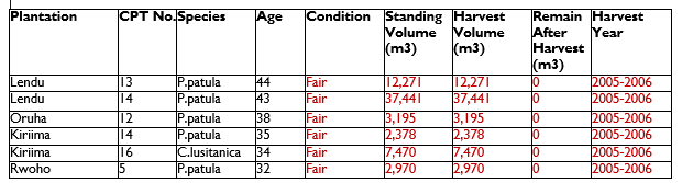
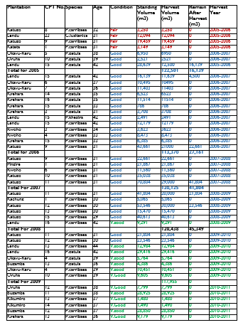
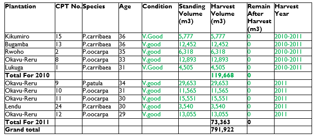
Table 11 shows an example of a 6-year harvesting plan that was prepared for all government plantations in 2005.
Table 11: An Example of a 6-Year Timber Plantation Harvesting Plan
Demarcation of felling coupes aims at packaging the standing crop in a way that the trees can be sold by public auction as required by the Public Procurement and Disposal of Public Assets Act, Regulations, and Guidelines. The NFA report on plantation inventory and harvesting plan gives guidance on delineation of harvesting coupes[1].
Instruction 289: The procedure below should be followed in establishing harvesting coupes.
a) Stocking verification and coupe dimensions:
• The volumes per hectare are mean volume per hectare for whole compartments. Stocking variations can occur from within the compartment. To ensure that each coupe has uniform per hectare stocking, stock verification should be done.
• A walk through the compartment is conducted and any variations of stocking within the compartment are noted. Where variations are observed, relascope sweeps are carried out, volumes computed, and the necessary adjustments made. Areas found to have irregular stocking i.e. scattered trees and patches are excluded.
• Coupes are demarcated / established on areas of regular and uniform stocking. Any unavoidable gaps within the coupes are catered for by volume adjustments. Coupe areas with volumes higher or lower than the earlier compartments are accordingly adjusted.
• The targeted volume per coupe is recommended at 2000m3 based on an average stocking of 400m3/ha and coupe area of 5ha. Areas of 5ha are easy to establish and dispose. Some coupes of less or more than 5ha may not be avoided for practical reasons. Patches of crop of smaller areas may for example be nested in the corners of bigger coupes.
b) Ground Demarcation of Coupes
Ground surveying using prismatic/ Sunto compasses and linear tapes is done. This has been found to be quick and reliable. The coupe dimensions are plotted on management maps after stock verification right in the field using a GPS. These shape maps are uploaded on the FMIS, later to be used to locate the coupes on the ground during inspection.
Upon locating the coupes on the ground, coupe boundaries are marked by painting trees nearest to or on the line separating adjacent coupes. Different colours (red and yellow) are used on adjacent coupes. No assumption of boundary will be made, as painting will be done round coupes. Corners of the coupes are enhanced with at least two corner trees brazed and coupe numbers written on them using blue paint. Blue and white colours are reserved for internal partitions.
c) Coupe Partitioning:
All coupes measuring over 3.5ha are sub divided into 3 parts. Volume/area portions of 20%, 40% and 40% are clearly marked on ground to facilitate subsequent monitoring of harvesting of the coupe by field staff. A line of trees painted with blue indicates the boundary of the 20% portion and these trees are not part of this portion and shall not be harvested without clearance to proceed to the 40% portion. White colour will be used to separate the two portions of 40% each, the line trees shall not be harvested until clearance for the final 40%. The 20% (harvest first) is in most cases located at the coupe entry (the easiest point of accessibility to the coupe).
Coupes of less than 3.5ha to 2 ha are sub divided into two halves (50%) and a blue line used to separate the units. Small coupes of about 1 ha are left as whole units (100%). A detailed table on area and volume of the sub division is processed.
d) Coupe numbering:
Serial numbering for coupes in each plantation should be done. The numbering starts with the first coupe to be demarcated, to the last, regardless of the compartment in which the coupe is located. Lendu for example has 21 coupes; the numbers run from 1 to 21. Sign boards/labels are made bearing the compartment no., species, coupe no., area and volume. The labels are pinned on the nearest tree at the beginning of the coupe.
Numbering should continue serially for the plantation as a whole. To further ensure proper coupe identification in case of loss of label, two or more big trees nearest to the beginning of all corners of the coupe are brazed and coupe numbers written on them using blue paint.
e) Coupe information
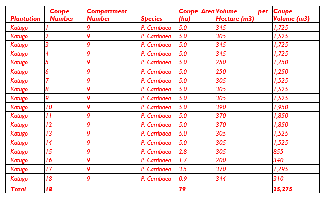
All the coupes demarcated should have a map produced showing their locations. A table containing all essential information pertaining to coupes shall be produced in the format of the example given in Table 12.
Table 12: Example plantation felling coupe details
NFA, 2005. Plantation Inventory Updates and Harvesting Plan (Final Report) ↩︎