¶ CHAPTER 1: PHYSICAL DESCRIPTION
¶ 1.1 NAME, LOCATION, BOUNDARIES AND AREA
¶ 1.1.1 Name, Location and Area
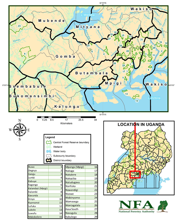
The Mpanga Management Plan Area (MPA) consists of twenty-nine (29) central forest reserves (CFRs) located in the three counties of Mawokota, Butambala and Gomba in Mpigi, Butambala and Gomba districts (Table 1), on the western shores of Lake Victoria. They are situated between latitude 00 0” and 00 30” N and between longitude 310 45” and 320 30” E (Map 1)
The total area covered by the CFRs in the MPA is 22,957 ha.
Table 1: Location of CFRs in Mpanga MPA (Sector)
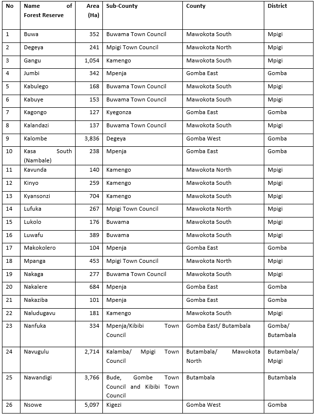
Source: Statutory Instrument 1998
¶ 1.1.2 Boundaries and Maps
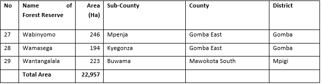
The total boundary length of the 29 CFRs in the MPA is 906.24 Km of which 899.96 Km are cut lines while 6.28 Km are natural features. Only about 437 Km of the total boundary length has been resurveyed, opened and demarcated with concrete pillars. The CFRs with clear boundaries are; Buwa, Gangu, Luwafu and Nsowe. The Table 2 below shows the respective CFR map sheet reference, boundary plan or land registration numbers and the boundary lengths.
Table 2: Boundary Plans and Maps
Source: NFA Boundary and Survey Unit
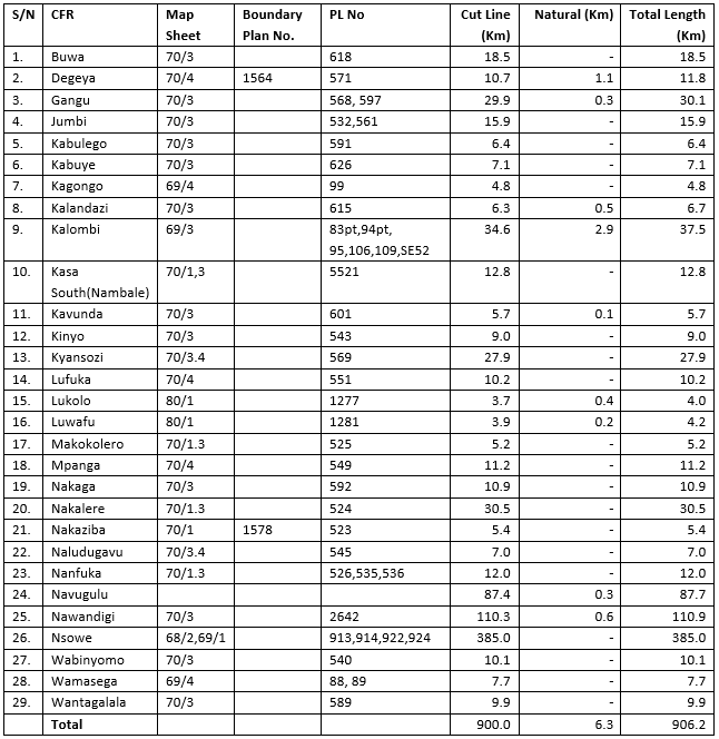
Map 1 shows the location of the CFRs in Mpanga Sector (MPA).
Map 1: Map of Mpanga MPA
¶ 1.2 LEGAL STATUS
¶ 1.2.1 Ownership
The 29 CFRs in the MPA were last gazetted as CFRs under Statutory Instrument 1998 number 63. However, the first gazettement of individual CFRs is given in the profiles (Appendix 1). The CFRs are managed subject to the provisions of the National Forestry and Tree Planting Act 2003 and their management and control is vested in the National Forestry Authority (NFA).
¶ 1.2.2 Privileges to the Local Communities
The local communities living around the reserves have the following privileges
• Renting CFR land for private tree planting.
• Access to forest food e.g. white ants, mushrooms, fruits
• Collection of herbal medicine for domestic use
• Access to water points e.g. in Kyansonzi, Lufuka, Luwafu CFRs
• Collection of firewood for domestic use from CFRs.
• Access to flora and fauna especially in the CFRs that still have patches of tropical high forest for education purposes for schools and local communities.
• Access to clay for brick making
• Access to grazing land
• Collection craft material
¶ 1.2.3 Rights
The rights to the local communities include: collection of firewood, water, herbal medicines, forest foods (white ants, edible grass hoppers – ensenene, fruits), craft materials, etc.
¶ 1.3 TOPOGRAPHY AND ALTITUDE
Mpanga MPA CFRs occupy valley bottoms of typical Buganda landscape with an altitudinal range of 1124-1280 metres above sea level. The lowest point is situated in Lukolo while the highest is found at Nakalere CFRs respectively. The average altitude of the CFRs in the MPA is 1177m asl. Over 89% of the forest area has slopes of less than 5o (Nature Conservation Master Plan 1999 vol 1).
For instance, Degeya, Jumbi and Buwa CFRs are found in valleys and are regarded as riverine forests while Lukolo and Luwafu CFRs are found on the island of Lake Victoria. These are part of Lake Victoria watershed areas in addition to all other CFRs on the western shores of Lake Victoria. The highest slope of the CFRs in the MPA is 38º in Kagogo CFR (Mpigi DDP, 2020).
¶ 1.4 SOILS, GEOLOGY AND DRAINAGE
¶ 1.4.1 Soils
The soils in the MPA, like the bigger part of Buganda region, are ferralitic and have been described as soils of very high to high productivity. They are associated with pre-cambean rock and recent alluvials. Their nutrient status indicates a high content of humus in the topsoil and high exchangeable bases. Their topsoil pH is 6.0 or below. The soil nutrient status is moderate to good depending on previous cultivation history and amount of accelerated erosion in the past.
¶ 1.4.2 Geology
The geology of the MPA is described as Buganda-Tooro system. It’s formed from predominant rocks found in Uganda which were formed between 3,000 and 6,000 million years ago in the Pre-cambean era.
¶ 1.4.3 Drainage
Luwafu and Lukolo CFRs that are situated close to L. Victoria have rivers that flow through them, eventually draining into Lake Victoria. The other CFRs have seasonal streams that also drain into the lake. The streams include Binyomo, Nakito, and Kyekokoto in Wabinyomo, Wamasega and Nakalere CFRs respectively.
Map 2 shows the drainage within Mpanga MPA.
Map 2: Mpanga MPA drainage map
¶ 1.5 CLIMATIC CONDITIONS
¶ 1.5.1 Rainfall
The MPA experiences a bi-modal rainfall pattern with first rains occurring between March and May and second rains coming between September and November. The average rainfall amounts to 1,320 mm though in many areas around the Lake zone it is between 1,750mm and 2,000mm.
The bi-modal type of rainfall is conducive for rain fed agricultural production including tree growing (Mpigi DDP, 2020).
¶ 1.5.2 Temperature
The area has average annual maximum temperatures ranging between 22.50C and 270C. Average relative humidity ranges between 80% and 95% especially in forest areas. The average monthly days of rainfall are 11. The minimum temperature in the area is 110 C while the maximum recorded so far is 33.30C (Mpigi DDP, 2020).
¶ 1.6 VEGETATION AND EXISTING CROP
¶ 1.6.1 Vegetation
Apart from Mpanga, parts of Gangu, Nawandigi, Nakaga, Navugulu, Lukolo and Luwafu which are mildly to heavily disturbed tropical moist forests (TMFs) also sometimes referred to as tropical high forests (THFs) or natural high forests (NHFs) and classified as type C2 (Piptadeniastrum-Albizia-Celtis), the rest of the CFRs in the sector were totally degraded and have been transformed into Eucalyptus plantations. Some CFRs have got patches of swampy forest which is classified as type XI (Cyperus papyrus swamp). The Table 3 below shows the summary of the current land cover types for the MPA.
Table 3: Land cover types of the Mpanga MPA
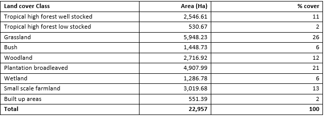
Source: Derived from NFA- GIS Unit data
¶ 1.6.2 Existing Crop
Mpanga CFR can currently be considered as fairly stocked with mature trees which include the following species; Funtumia, Celtis, Albizia, Maesopsis, Lovoa, Morus lactea, Trema orientalis, Antiaris toxicaria, Prunus africana, Polyscias fulva, Cedrella odorata. The tree species mentioned are evenly distributed with more mature trees close to roads and other pathways. In the interior of the forests, however, young trees are commonly seen. Some of the tree species found in the CFRs fall in the IUCN Red List of Endangered Species (Appendix 2) and therefore need a lot of protection.
Other Tropical Moist CFRs that are fairly stocked but with immature trees include, parts of Gangu, Nakalere, Nawandigi, Nakaga, Navugulu, Luwafu and Lukolo. However, these CFRs were previously heavily degraded although were restored with support from partners such as Serena Hotel, Uganda Breweries, Standard Chartered Bank and Rotary Club with exception of Lukolo.
Buwa and Degeya CFRs which are partly swampy have a number of palms (Phoenix reclinata) which are sparsely distributed and are being harvested illegally.
The rest of the CFRs were greatly degraded and were leased out to private tree growers. They are growing Eucalyptus mainly, under license, for firewood, timber, construction (building) and transmission poles. The Eucalyptus crop is of varying species, ages and sizes. The main species grown are Eucalyptus grandis, E. camaldulensis; Eucalyptus clones (GC and GU).